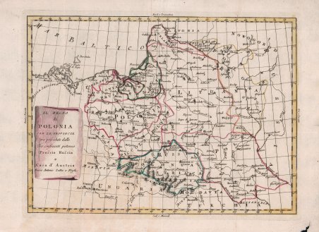
Questo sito usa cookie di analytics per raccogliere dati in forma aggregata e cookie di terze parti per migliorare l'esperienza utente.
Leggi l'Informativa Cookie Policy completa.

Stampe

ZATTA Antonio

Il Regno di Polonia con le Provincie ora possedute dalle Tre confinanti potenze Prussia Russia e Casa d'Austria

1795

250,00 €

Antiquarius Libreria

(Roma, Italia)

Parla con il Libraio

Metodi di Pagamento

Dettagli

Anno di pubblicazione
1795
Luogo di stampa
Venezia
Formato
330 X 245
Incisori
ZATTA Antonio

Descrizione

Rara carta della Polonia firmata con imprint "Antonio Zatta e Figli". Sebbene priva di data la carta è ricondotta a circa il 1795 per motivi storici.Le spartizioni della Polonia avvennero nel XVIII secolo e posero fine all'esistenza della Confederazione polacco-lituana. Le spartizioni coinvolsero la Prussia, l'Impero Russo e l'Impero austriaco, che si divisero le terre della confederazione. Le tre spartizioni avvennero: il 5 agosto 1772; il 23 gennaio 1793; il 24 ottobre 1795. Dopo le guerre napoleoniche, durante le quali Napoleone Bonaparte ricostruì, nella forma del Ducato di Varsavia, uno stato polacco, Regno di Prussia, Impero Russo ed Impero d'Austria si spartirono la Polonia in 3 parti, che erano: il Granducato di Pozna?, annesso al Regno di Prussia; la Repubblica di Cracovia; nil Regno di Polonia, conosciuto come Regno del Congresso.Bell'esemplare con coloritura coeva, inciso su rame, in ottimo stato di conservazione. Rare map of Poland, in the midst of its dismemberments. Although undated, the map is traced back to around 1795 for historical reasons.The Partitions of Poland were three partitions of the Polish–Lithuanian Commonwealth that took place toward the end of the 18th century and ended the existence of the state, resulting in the elimination of sovereign Poland and Lithuania for 123 years. The partitions were conducted by the Habsburg Monarchy, the Kingdom of Prussia, and the Russian Empire, which divided up the Commonwealth lands among themselves progressively in the process of territorial seizures and annexations.The First Partition of Poland was decided on August 5, 1772. Two decades later, Russian and Prussian troops entered the Commonwealth again and the Second Partition was signed on January 23, 1793. Austria did not participate in the Second Partition. The Third Partition of Poland took place on October 24, 1795, in reaction to the unsuccessful Polish Ko?ciuszko Uprising the previous year. With this partition, the Commonwealth ceased to exist.The map locates the Polish territorial acquistions of Russia, Austria and Prussia in the second half of the 18th Century.The map of present-day Poland, Lithuania, and portions of Latvia, Belarus, and Ukraine, identifying the cities of Warsaw, Krakow, Kiev, Minsk, and Riga, extending into Austria to show Vienna.Etching, original outline colour, in good condition. Cfr.
Logo Maremagnum it