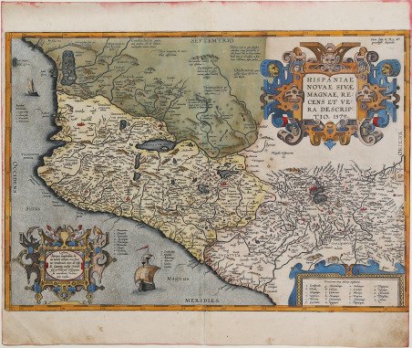
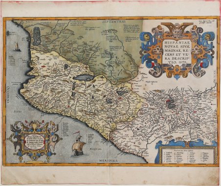
Carta del Messico dal Theatrum Orbis Terrarum, edizione spagnola del 1608. Questa carta, fonte di ispirazione per De Bry, Quad e Hondius, ha costituito il principale modello per la rappresentazione di questa regione per tutta una generazione. Sebbene Herrera (Cosmografo Reale Spagnolo) e Wytfliet iniziassero al loro produzione cartografica ben 20 anni dopo Ortelius, tuttavia la loro opera fu nettamente inferiore. Entrambi i cartigli inseriti della mappa sono copie dei disegni di Hans Vredeman de Vries, pubblicati per essere utilizzati dai cartografi, che realizzavano i disegni sul rame in modo che, una volta stampati, fossero lo specchio dell’originale. La mappa mostra l'area che, approssimativamente, corrisponde ai moderni stati messicani del Michoacan, Jalisco, Mayarit, e Guerrero, nonché la Valle dei Messico. Edizione spagnola del 1608. Il ' Theatrum Orbis Terrarum ' e che è considerato il primo vero “atlante” moderno. L’opera fu pubblicata in 7 lingue e 36 edizioni, per il quale – nel 1570 - Ortelius ottenne il ' privilegio, ovvero una sorta di diritto d'autore che impediva ad altri cartografi di pubblicare i propri lavori. Il ' Theatrum ' rappresentava il lavoro più avanzato del lavoro della descrizione cartografica. L’Ortelius vi raccolse il sapere geografico e cartografico del suo tempo, proponendo in 147 spettacolari tavole incise l’immagine più fedele del mondo allora conosciuto e, in alcune straordinarie “carte storiche”, regioni e itinerari tratti dalla letteratura, dalla mitologia, dalla tradizione. Ortelius fu anche il primo a citare le fonti, menzionando i nomi dei cartografi nel “catalogus auctorum”. Dal 1598 al 1612 le edizioni postume del ' Theatrum ' furono realizzate dal suo collaboratore Johannes Baptiste Vrients. Incisione in rame, eccellente coloritura coeva, in ottimo stato di conservazione. Nice example of Ortelius' map of western New Spain, showing the recently-created Spanish settlements, many rivers, and large lakes, including Lake Chapala and a mythical sea with islands in the northwest.The map shows an area corresponding roughly to the modern Mexican states of Michoacan, Jalisco, Mayarit, and Guerrero, plus the Valley of Mexico. This was the standard map of the area for a generation, copied by De Bry, Quad and Hondius. Even though Herrera ( Spain 's Royal Cosmographer) and Wytfliet worked 20 years after Ortelius, they produced inferior maps of the area. Both cartouches in the map are copies of designs by Hans Vredeman de Vries. These were published for use by engravers, who would trace the patterns onto the copper plates, creating a mirror image of the original design when printed. ' Map taken from the ' Theatrum Orbis Terrarum, which is considered the first true modern "Atlas". The work was published in 7 languages and 36 editions, for which - in 1570 - Ortelius obtained the privilege, a kind of copyright that prevented other cartographers from publishing his works. The ' Theatrum ' represented the most advanced work of cartographic description. Ortelius collected in it the geographical and cartographic knowledge of his time, proposing in 147 spectacular engraved plates the most faithful image of the world then known and, in some extraordinary "historical maps", regions and routes taken from literature, mythology, tradition. Ortelius was also the first to cite sources, mentioning the names of cartographers in the "catalogus auctorum". From 1598 to 1612 the posthumous editions of the ' Theatrum ' were made by his collaborator Johannes Baptiste Vrients. Spanish edition of 1608. ' Copperplate with fantastic original colouring, in very good condition. Cfr. M. Van den Broecke "Ortelius Atlas Maps" (2011), n. 13.


Scopri come utilizzare
Scopri come utilizzare

