Dettagli
Anno di pubblicazione
1608
Incisori
VRIENTS Johannes Baptiste
Descrizione
Van den Broecke, Ortelius, n. 133; (Koeman Atlantes Neerlandici III): 157.
Descrizione
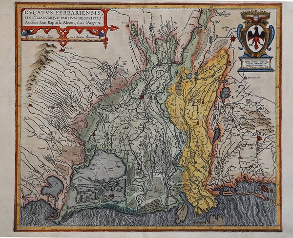
Rara carta del territorio di Ferrara pubblicata da J. B. Vrients nel 1608 nella sua edizione del Theatrum Orbis Terrarum di Abraham Ortelius.La mappa si basa sulla carta del ferrarese Giovanni Battista Aleotti, più volte stampata a partire dal 1600 in diverse versioni silografiche e in rame.Vrients acquistò i rami delle carte di Ortelius dopo la sua morte (1598) ristampando ed ampliando l'atlante orteliano. Questa di Ferrara è una delle, poche, carte aggiunte. Il Theatrum Orbis Terrarum ' è considerato il primo vero “atlante” moderno. L’opera fu pubblicata in 7 lingue e 36 edizioni, per il quale – nel 1570 - Ortelius ottenne il privilegio, ovvero una sorta di diritto d'autore che impediva ad altri cartografi di pubblicare i propri lavori. Il Theatrum rappresentava il lavoro più avanzato del lavoro della descrizione cartografica. L’Ortelius vi raccolse il sapere geografico e cartografico del suo tempo, proponendo in 147 spettacolari tavole incise l’immagine più fedele del mondo allora conosciuto e, in alcune straordinarie “carte storiche”, regioni e itinerari tratti dalla letteratura, dalla mitologia, dalla tradizione. Ortelius fu anche il primo a citare le fonti, menzionando i nomi dei cartografi nel “catalogus auctorum”. Dal 1598 al 1612 le edizioni postume del Theatrum furono realizzate dal suo collaboratore Johannes Baptiste Vrients. ' Acquaforte, finemente colorata a mano, in perfetto stato di conservazione. Esemplare con testo italiano al verso, riconducibile al 1608 o 1612. Rare early map of the Duchy of Ferrara, first published in Ortelius's Theatrum Orbis Terrarum in 1608.This rare and handsome map centers on Ferrara, a city that became one of the great cultural centers of Italy in the 15th and 16th centuries under the reign of Ercole d'Este I, and later Alfonso II. The fertile region surrounding Ferrara is well depicted with its extensive river systems and valleys. Oriented with north to the right, the map extends to include Venice, Bologne, and the lagoons of the Valli di Comacchio. This map was based on a single sheet map of the area by Giovanni Battista Aleotti in 1603. Italian text on verso, published in 1608 and 1612with the same typesetting on verso. TThis map was among the additions made by Vrients when he took over publication of the Theatrum after Ortelius' death. It was published in relatively few editions and is very uncommon. The Theatrum Orbis Terrarum, is considered the first true modern "Atlas". The work was published in 7 languages and 36 editions, for which - in 1570 - Ortelius obtained the privilege, a kind of copyright that prevented other cartographers from publishing his works. The Theatrum represented the most advanced work of cartographic description. Ortelius collected in it the geographical and cartographic knowledge of his time, proposing in 147 spectacular engraved plates the most faithful image of the world then known and, in some extraordinary "historical maps", regions and routes taken from literature, mythology, tradition. Ortelius was also the first to cite sources, mentioning the names of cartographers in the "catalogus auctorum". From 1598 to 1612 the posthumous editions of the Theatrum were made by his collaborator Johannes Baptiste Vrients. Copper engraving, contemporary coloring, in good condition. Cfr. Van den Broecke, Ortelius, n. 133; (Koeman Atlantes Neerlandici III): 157.


Scopri come utilizzare
Scopri come utilizzare

