Dettagli
Anno di pubblicazione
1645
Incisori
DUDLEY ROBERT - LUCINI ANTON FRANCESCO
Soggetto
Angola, Guinea, Congo
Descrizione
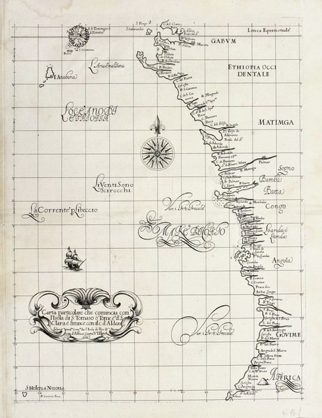
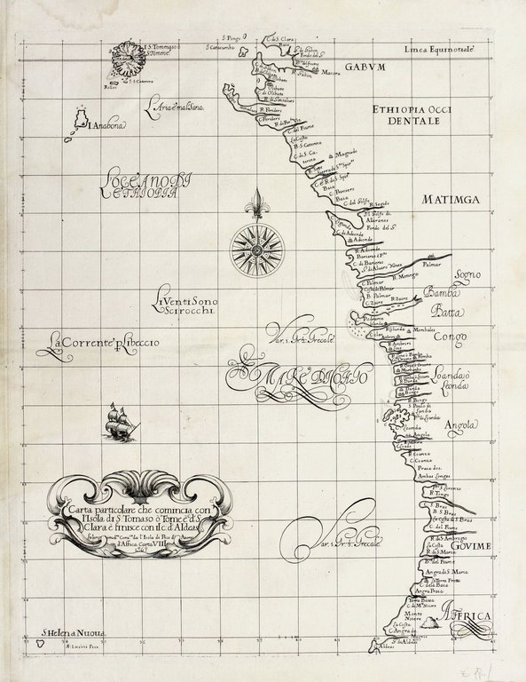
Incisione in rame, mm 485x378. La carta raffigura la costa dall'isola di Saõ Tomé e capo Santa Clara nel Gabon verso sud descrivendo le coste di Congo, Angola e Namibia; tratta da "Dell'Arcano del Mare" di Robert Dudley (1574-1649), che rappresenta il primo atlante marittimo del mondo intero stampato da un inglese e ad usare la proiezione di Mercatore e la declinazione magnetica. Le mappe sono tutte originali, caratterizzate dalla particolare decorazione barocca di Lucini. Dudley lasciò l'Inghilterra nel 1605 e si trasferì al servizio di Cosimo II, Gran Duca di Toscana come ingegnere e comandante navale. Nel 1646, dopo 12 anni di fatica, pubblicò l'atlante. Lucini, l'incisore nacque a Firenze, fu allievo di Callot e amico di Della Bella. A lui si deve la finezza incisoria e la bellezza del testo inciso "alla Cancelleresca". Robert Dudley's "Arcano del mare" is "one of the greatest atlases of the world and one of the most complex ever produced: it is the first sea-atlas of the whole world; the first with all the charts constructed using Mercator's new projection, as corrected by Edward Wright; the first to give magnetic declination; the first to give prevailing winds and currents. the first to expound the advantages of "Great Circle Sailing"; and the first sea-atlas to be compiled by an Englishman." (Lord Wardington). Ottimo esemplare. <BR>Copper engraving, mm 475x750. The map shows south-west Africa coast, the earliest obtainable sea chart of the region. It shows the coastline of Namibia and Angola. Second state (with L°6° added in the cartouche). From "Dell'Arcano del mare", the first english nautical atlas and the first maritime atlas to use the mercator projection first edition. Robert Dudley's "Arcano del mare" is "one of the greatest atlases of the world and one of the most complex ever produced: it is the first sea-atlas of the whole world; the first with all the charts constructed using Mercator's new projection, as corrected by Edward Wright; the first to give magnetic declination; the first to give prevailing winds and currents. the first to expound the advantages of "Great Circle Sailing"; and the first sea-atlas to be compiled by an Englishman." (Lord Wardington). <BR>Dudley left England in 1605. Arriving in Florence, Dudley entered the service of the Cosimo II, Grand Duke of Tuscany, as an engineer and naval commander. In 1646, Dudley published "Arcano del mare", the whole written in Italian by Dudley himself. The atlas was twelve years in the making, and the main innovation lay in its conception of a world atlas of charts, both general ocean charts and detailed surveys, covering all the rival spheres of European dominion: Spanish, English and Dutch. Dudley's sources included the original charts of Henry Hudson, and for the Pacific coast he used the observations of Henry Cavendish, the third circumnavigator of the globe and Dudley's brother-in-law. <BR>Antonio Francesco Lucini, the engraver, was born in Florence c. 1610. He was a pupil of Callot and a friend of Stefano della Bella. Before being employed by Sir Robert Dudley, he had already published engraved views of Florence and scenes of the Turkish Wars. Lucini put the stamp of his personality on the finished work as well as did the author; the delicacy and strength of the engraving, the embellishments of the lettering "alla cancellaresca", make it a true example of Italian Baroque art. In a printed introductory leaf found in one copy in the British Library, Lucini states that he worked on the plates in seclusion for twelve years in an obscure Tuscan village, using up to no less than 5,000 lbs (2,268 kg) of copper. According to the engraver, the Arcano del Mare took forty years to prepare and twelve to execute. (Sotheby's Catalogue, Wardington Sale, 2005)<BR>The chart is embellished with a finely engraved ship and fine compass rose, and has the lush calligraphy of the engraver, Lucini. <BR>


Scopri come utilizzare
Scopri come utilizzare

