Détails
Graveurs
Andriveau-Goujon Eugène
Description
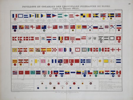
Carta molto decorativa, originariamente colorata a mano, delle bandiere e delle coccarde di tutte le nazioni che solcavano il mare, preparata da J. Andriveau-Goujon e pubblicata nel suo "Atlas Universel". ' Mostra le bandiere dei principali paesi del mondo, comprese le bandiere regionali, navali, diportistiche e di altro tipo dei principali paesi europei. Eugène Andriveau-Goujon (1832 - 1897) fu un editore di mappe e cartografo attivo nella Parigi del XIX secolo. L'azienda fu creata nel 1825 quando Eugène Andriveau sposò la figlia dell'editore di mappe Jean Goujon, dando così vita ad Andriveau-Goujon. Le mappe di Andriveau-Goujon sono spesso confuse da identificare in quanto possono essere alternativamente denominate J. Goujon, J. Andriveau, J. Andriveau-Goujon, E. Andriveau-Goujon o semplicemente Andriveau-Goujon. Ciò si riferisce alle molteplici generazioni della dinastia Andriveau-Goujon e alla tendenza a ripubblicare materiale più vecchio senza aggiornare l'impronta. Le prime mappe con l'imprint Andriveau-Goujon furono pubblicate da Jean Andriveau-Goujon. Egli passò l'attività al figlio Gilbert-Gabriel Andriveau-Goujon, che nel 1858 passò al figlio Eugène Andriveau-Goujon, sotto la cui gestione l'azienda fu più prolifica. Andriveau-Goujon pubblicò numerose mappe tascabili e atlanti di pregio per tutto il XIX secolo e collaborò spesso con altri importanti cartografi francesi dell'epoca, come Brue e Levasseur. Lo stock della ditta fu acquisito da M. Barrère nel 1892. Litografia con colori originali a mano, ottimo stato di conservazione. Very decorative originally hand colored chart of flags and rosettes of all sea fearing nations, prepared by J. Andriveau-Goujon and published in his "Atlas Universel". ' Fantastic double page image, showing the flags of the major countries of the World, including regional, naval, yachting and other flags for the major countries of Europe. Eugène Andriveau-Goujon (1832 - 1897) was a map publisher and cartographer active in 19th century Paris. The firm was created in 1825 when Eugène Andriveau married the daughter of map publisher Jean Goujon - thus creating Andriveau-Goujon. Maps by Andriveau-Goujon are often confusing to identify as they can be alternately singed J. Goujon, J. Andriveau, J. Andriveau-Goujon, E. Andriveau-Goujon, or simply Andriveau-Goujon. This refers to the multiple generations of the Andriveau-Goujon dynasty and the tendency to republish older material without updating the imprint. The earliest maps to have the Andriveau-Goujon imprint were released by Jean Andriveau-Goujon. He passed the business to his son Gilbert-Gabriel Andriveau-Goujon, who in 1858 passed to his son, Eugène Andriveau-Goujon, under whose management the firm was most prolific. Andriveau-Goujon published numerous fine pocket maps and atlases throughout the 19th century and often worked with other prominent French cartographers of the time such as Brue and Levasseur. The firm's stock was acquired by M. Barrère in 1892. Litograph with original hand colour, very good condition. Cfr.


Découvrez comment utiliser
Découvrez comment utiliser

