Questo sito usa cookie di analytics per raccogliere dati in forma aggregata e cookie di terze parti per migliorare l'esperienza utente.
Leggi l'Informativa Cookie Policy completa.

Gravures

REILLY Franz Johann von

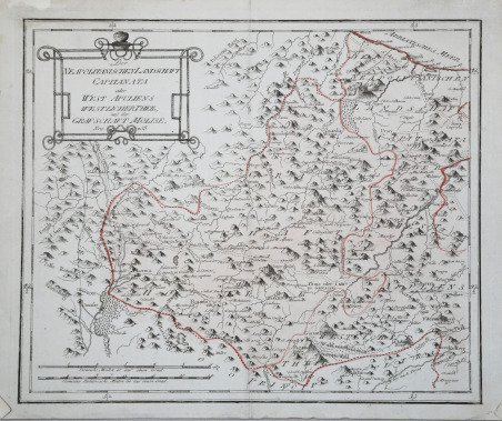
Neapolitani schen Landschaft Capitanata.

1791

125,00 €

Antiquarius Libreria

(Roma, Italie)

Demander plus d'informations

Mode de Paiement

Détails

Année
1791
Lieu d'édition
Vienna
Format
340 X 280
Graveurs
REILLY Franz Johann von

Description

Pubblicata a Vienna da Franz Johann Joseph von ' Reilly nello ' Schauplatz der fünf Theile der Welt mit beständiger Rücksicht auf die besten Originalwerke in drey Theile zusammengetragen von einer Gesselschaft Geographen nach zu Büschings Grosser Erdbeschreibung. Reilly (1766-1820) pubblicò l’atlante al ritmo di una mappa a settimana per 17 anni dal giugno 1789 al luglio 1806, producendo, in totale, circa 830 mappe dell'Europa. Una terza parte dell'atlante era prevista per coprire il resto del mondo, ma non fu mai pubblicata. ' Come si deduce dal titolo dell'Atlante in cui la mappa è stata pubblicata la prima volta, l'autore del disegno è il cartografo tedesco Anton Friederich Büschings e l'incisore è Ignaz Albrecht'. L'Atlante fu pubblicato dal mercante d'arte viennese Franz Johann Joseph von Reilly (1766-1820) che tra il 1789 e il 1806 - proprio nel periodo delle campagne napoleoniche, quando i confini erano piuttosto labili- produsse almeno 830 mappe e quelle riguardanti l'Italia furono pubblicate tra l'agosto 1797 e il giugno 1799. Acquaforte, stampata su carta azzurra e con coloritura editoriale, in ottimo stato di conservazione. Published in Vienna by Franz Johann Joseph von Reilly in ' Schauplatz der fünf Theile der Welt mit beständiger Rücksicht auf die besten Originalwerke in drey Theile zusammengetragen von einer Gesselschaft Geographen nach zu Büschings Grosser Erdbeschreibung. Reilly (1766-1820) published the Atlas at the rate of one map per week for 17 years from June 1789 to July 1806, producing, in total, some 830 maps of Europe. A third part of the atlas was planned to cover the rest of the world, but was never published. As can be deduced from the title of the Atlas in which the map was first published, the author of the drawing was the German cartographer Anton Friederich Büschings and the engraver was Ignaz Albrecht. The Atlas was published by the Viennese art dealer Franz Johann Joseph von Reilly (1766-1820) who produced at least 830 maps between 1789 and 1806 - right in the period of the Napoleonic campaigns, when the borders were rather labile - and those concerning Italy were published between August 1797 and June 1799. Etching, printed on blue paper and with editorial colouring, in excellent condition. Cfr.