Détails
Graveurs
CORONELLI Vincenzo
Description
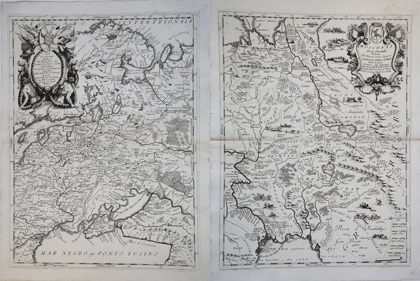
Dettagliata mappa su due fogli della Russia, descrive i territori che si estendono dal Mar Baltico e dal Mar Nero, ad occidente, fino alla Gran Tartaria, ad Oriente.La mappa della Russia di Coronelli è una delle mappe più dettagliate ed elaborate del XVII secolo e fornisce numerosi dettagli, nell'elegante stile che caratterizza le mappe dell'autore. La mappa è ulteriormente impreziosita da due elaborati cartigli decorativi e da numerose disegni di popoli indigeni, villaggi, scene di caccia, animali, ecc.; incluse le rappresentazioni delle tribù nomadi che si estendono a nord dal Mar Caspio fino ad est del Golfo di Nova Zemblja e ai guerrieri Cosacchi nella parte sudorientale della mappa. Opera tratta dal ' Corso geografico universale, o sia la terra divisa nelle sue parti e subdistinta ne' suoi gran regni. Esposta in tavole geografiche ricorrette et accresciute di tutte le nuove scoperte, ad uso dell'Accademia Cosmografica degli Argonauti dal Padre Maestro Vincenzo Coronelli M. C. Cosmografo della Serenissima Republica di Venetia. Dedicata alla Santità di Nostro Signore Innocenzo XII. P. I. In Venetia, a spese dell'autore. MDCXCII. Coronelli visse un periodo di straordinaria fecondità editoriale a partire dal 1689, quando ebbe la cattedra di geografia presso l'Università alle Procuratie, con la pubblicazione, nel 1690, del primo volume dell'Atlante Veneto. In effetti sotto il nome di ' Atlante Veneto ' va tutta la raccolta di tredici opere composte nell'arco del decennio successivo, dall'Isolario ' allo ' Specchio del mare. In realtà solo alcune di tali opere possono definirsi atlante, e sono di valore molto disuguale, dato che si passa da opere originali e fondamentali come quelle citate o il ' Corso Geografico ' ad opere di compilazione o semplici raccolte di vedute. Il ' Corso Geografico ' uscì in diverse edizioni con numeri diversi di carte - sessantotto tavole nel 1689-92; di centosettantatré tavole nel 1692; duecentosessanta tavole, nel 1694-97 - che venivano vendute anche separatamente, al ritmo di sei carte al mese per due anni. Le carte furono incise tra il 1688 e il 1692 nell'attrezzatissima officina cartografica del convento dei Frari, dove lavoravano anche incisori stranieri. ' Nice example of Coronelli's two sheet map of Russia, extending from the Baltic and the Black Sea in the west to Gran Tartaria in the East.Coronelli's map of Russia is one of the most detailed and elaborate maps of the 17th Century, providing tremendous detail in the fine exacting style which characterizes Coronelli's maps. The map is further embellished by two elaborate decorative cartouches and many vignettes of indigenous peoples, villages, hunting, animals, etc, including depictions of the nomadic tribes extending north from the Caspian Sea to east of the Gulf of Nova Zembla and the Cosack warriors in the southeast part of the map. The map is taken from ' Corso geografico universale, o sia la terra divisa nelle sue parti e subdistinta ne' suoi gran regni. Esposta in tavole geografiche ricorrette et accresciute di tutte le nuove scoperte, ad uso dell'Accademia Cosmografica degli Argonauti dal Padre Maestro Vincenzo Coronelli M. C. Cosmografo della Serenissima Republica di Venetia. Dedicata alla Santità di Nostro Signore Innocenzo XII. P. I. In Venetia, a spese dell'autore. MDCXCII. Coronelli lived a period of extraordinary editorial fecundity starting from 1689, when he had the chair of geography at the University at the Procuratie, with the publication, in 1690, of the first volume of the ' Atlante Veneto. Under the name of ' Atlante Veneto ' goes the entire collection of thirteen works composed over the next decade, from the ' Isolario ' to the ' Specchio del mare. ' In reality, only some of these works can be defined as atlas, and are of very unequal value, since we go from original and fundamental works such as those mentioned or the ' Corso Geografico ' to works of compilation or simple collections of views. The ' Corso Geografico ' came out in several editions with different numbers of maps - sixty-eight maps in 1689-92; one hundred and seventy-three maps in 1692; two hundred and sixty maps in 1694-97 - which were also sold separately, at the rate of six a month for two years. The maps were alle engraved between 1688 and 1692 in the well-equipped cartographic workshop of the Frari convent, where foreign engravers also worked. ' Cfr.


Découvrez comment utiliser
Découvrez comment utiliser

