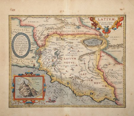
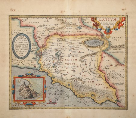
Bell'esemplare della mappa di Ortelius del Lazio, tratta dal Parergon di Ortelius, un atlante che rappresenta il mondo antico. Il Parergon fu generalmente pubblicato come appendice all'opera magna di Ortelius, il Theatrum Orbis Terrarum, che è considerato il primo atlante moderno. Tuttavia, il Parergon fu anche pubblicato come atlante separato in alcune occasioni, tra cui nel 1595 e nel 1624. Orientata verso nord, questa mappa si estende dal Mar Tirreno (Maris Tyrrheni) a sud fino alla regione dell'Umbria a nord, mostrando l'intera regione del Lazio così come parti delle regioni Toscana (Tusciae pars) e Campania (Campaniae pars). Le città sono rappresentate da edifici disegnati individualmente, nel tipico stile ortelico. Tre bellissimi cartigli adornano la mappa. Nell'angolo nord-est, il cartiglio del titolo è particolarmente ornato. Un cartiglio più semplice in Toscana dedica la mappa allo storico e patrizio Marcus Velser Augustanus. Il terzo cartiglio contiene un inserto della mappa del Monte Circeo (Mons Circaeus), e una nota indica che questa rappresentazione è stata fatta da Angelo Breventanus. Questo cartiglio contiene anche una semplice rosa dei venti, poiché il suo orientamento è diverso da quello della mappa più grande. Alcuni dettagli in questa mappa enfatizzano la storia e la mitologia associate a questa regione. Nel Mar Tirreno (Maris Tyrrheni), una nave naviga completa di rematori, soldati e due armi d'artiglieria, ricordando allo spettatore la potenza militare dell'Impero Romano. L'antica casa della maga Circe, che appare molto nell'Odissea di Omero, è nota a Circaeium. C'è anche una piccola descrizione al Lago Fucino (Fucinus Lacus), che indica che il lago contiene pesci con otto pinne, secondo Plinio. Il Parergon fu un progetto di interesse personale e l'opera che Ortelius stesso considerava il suo più grande risultato. Aveva un profondo interesse per l'antichità classica che lo spinse a creare le mappe del Parergon, e la quantità di tempo e di dettagli che mise in ogni mappa è chiaramente evidente. Ortelius disegnò a mano ogni mappa del Parergon, il che richiese una notevole abilità e conoscenza della storia e della geografia dell'area. È considerato il primo atlante storico. Circa una decade dopo la pubblicazione del “moderno” ' Theatrum Orbis Terrarum, Ortelius rispose alle “preghiere di amici e studiosi di storia antica, sacra e profana” e compilò una serie di mappe di soggetto biblico e classico, quasi tutte disegnate da lui. Intitolò l’opera “Parergon theatri”, ovvero “aggiunta, appendice, del ' Theatrum”, ma al tempo stesso anche complementare al ' Theatrum: ' il ' Paregon theatri ' forniva per il mondo antico lo stesso materiale che Ortelius aveva fornito per il mondo moderno con il ' Theatrum: carte geografiche. Lo spirito del Parergon è tutto riassunto nel motto ' historiae oculus geographia ' riportato sul frontespizio: la geografia è l’occhio della storia. Le mappe del mondo antico avevano lo scopo di “rendere più chiari gli storici antichi e i poeti”. Le mappe del ' Paregon ' sono di tre tipologie: antiche regioni; carte letterarie e carte bibliche. Come sottolinea Koeman “il ' Parergon ' deve essere considerato come lavoro personale di Ortelius. Per quest'opera, infatti, diversamente dal ' Theatrum, non copiò le mappe di altri cartografi, ma ne disegnò lui stesso di nuove ed originali. Riprese luoghi, regioni e territori delle civiltà classiche illustrandone e spiegandone la storia, una materia molto vicina al suo cuore. Le mappe e le lastre del ' Parergon ' devono essere valutate come le più importanti incisioni che rappresentano il diffuso interesse per la geografia classica nel XVI secolo”. “Nella primiera descrittion del divo Augusto è di due maniere il Latio, il vecchio cioè & il nuovo, cosi ominato. Il vecchio si spande dal Tevere infin al monte Circello.ma il nuouo d'indi infin al fiume Liri, ch'è il Garigliano, si come accer. Splendid historical map of the ancient Latium, published in Abraham Ortelius' ' Parergon. A second state (of three) of the plate; sometime between 1595L and 1601L the plate was revised thoroughly. The network of Roman roads around Rome was added and named. Designation of the swamps was extended in the lower right and among others, ' VOLCI ' added. Title: ' LATIVM. ' | "Ex Conatibus Geographicis | Abrah. Ortelij Antverp". Lower right: "Cum priuilegio decennali, | Imp. Reg. et Brabantiæ. | 1595". Cartouche upper left: ' VIRO | NOBILI, ET | HISTORICO | ILLVSTRI, MAR:|CO VELSERO, PA:|TRICIO AVGVS:|TANO, ABRAHA:|MVS ORTELI:|VS DEDICA:|BAT, | L.M. [Dedicated by Abraham Ortelius to the noble gentleman and illustrious historian, the noble Marcus Velser Augustanus the patrician]. At lower edge an inset, 90 x 108 mm: ' MONS CIRCÆVS, AD | VIVVM DELINEATVS, AB | ANGELO BREVENTANO. [Mount Circæus, depicted true to nature by Angelo Breventanus]. Cartographic sources are numerous classical authors, specifically Vergilius, Plinius, Varro, Halicarnasseus, Festus and Ausonius. The inset, mount Circeo (South-East of Rome), is the supposed dwelling place of the mythical goddess/witch Circe, who enchanted Odysseus and turned his companions into swine. Ortelius' source for this inset map, Angelo Breventano, is described by him as "a man of good credit.and a most diligent searcher out of Roman antiquities". The ' Parergon ' is the first historical atlas ever published. It was initially conceived by Ortelius as an appendix to his ' Theatrum Orbis Terrarum ' but given the considerable success of these historical maps it later became an independent work and remained the main source of all similar works throughout the seventeenth century. Koeman wrote: “This atlas of ancient geography must be regarded as a personal work of Ortelius. For this work he did not, as in the ' Theatrum, ' copy other people's maps but drew the originals himself. He took many places and regions from the lands of classical civilization to illustrate and clarify their history, a subject very close to his heart. The maps and plates of the ' Parergon ' have to be evaluated as the most outstanding engravings depicting the wide-spread interest in classical geography in the 16th century." The ' Theatrum Orbis Terrarum, which is considered the first true modern "Atlas". The work was published in 7 languages and 36 editions, for which - in 1570 - Ortelius obtained the privilege, a kind of copyright that prevented other cartographers from publishing his works. The ' Theatrum ' represented the most advanced work of cartographic description. Ortelius collected in it the geographical and cartographic knowledge of his time, proposing in 147 spectacular engraved plates the most faithful image of the world then known and, in some extraordinary "historical maps", regions and routes taken from literature, mythology, tradition. Example with fine later coloring, paper slightly browned, otherwise in excellent condition. Bibliografia Cfr. L. Bagrow, ' A. Ortelli Catalogus Cartographorum; cfr. C. Koeman, ' Atlantes Neerlandici; ' Peter H. Meurer, ' Fontes Cartographici Orteliani ' 28p; M. Van den Broecke, ' Ortelius Atlas Maps, n. 209 II/III; Van der Krogt, ' Koeman’s Atantes Neerlandici: 7320H:31. ' Cfr.


Découvrez comment utiliser
Découvrez comment utiliser

