Détails
Description
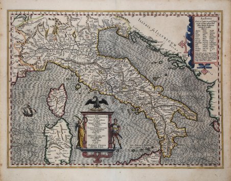
Carta storica della penisola di Philipp Cluver (Cluverio) per la prima volta pubblicata nel Theatrum Geographiæ Veteris di Bertius. Esemplare edito da Jodocus Hondius e tratto dall'edizione latina del Mercator/Hondius Atlas, circa 1630, dal titolo Atlantis Maioris Appendix, sive Pars Altera, . Amsterdam, J. Janssonius, 1630. (Van der Krogt 1, 1:202). Prima carta dedicata all'Italia dal grande umanista e geografo, considerato il vero fondatore della geografia storica. Con margini graduati e senza reticolato, l'opera è di chiara derivazione mercatoriana. Il titolo della carta si trova in alto a destra all'interno di un cartiglio su cui poggia un'aquila, decorato con motivi vegetali. La semiologia adottata è quella tipica del periodo, con i monti a mucchi di talpa arbitrariamente distribuiti. I fiumi sono delineati con un tratto forte, le coste sono tratteggiate esternamente. Una serie di puntini delimita i confini a Nord della penisola. È presente un veliero che solca il mare. Compaiono anche i nomi delle antiche popolazioni della penisola, oltre ai nomi di epoca romana delle varie regioni storiche. Incisione in rame, finemente colorata a mano, minimi restauri visibili al verso, per il resto in ottime condizioni. Bibliografia Van der Krogt 1, 7000H:1A.1; Borri, 68; ' R. Borri "L'Italia nelle antiche carte…" (2011), scheda 87. Historical map of the peninsula by Philipp Cluver (Cluverius) first published in Bertius' Theatrum Geographiæ Veteris. Example edited by Jodocus Hondius and taken from the Latin edition of the Mercator/Hondius Atlas, circa 1630, entitled Atlantis Maioris Appendix, sive Pars Altera, . Amsterdam, J. Janssonius, 1630. (Van der Krogt 1, 1:202). First map dedicated to Italy by the great humanist and geographer, considered the true founder of historical geography. With graduated margins and no reticulation, the work is clearly Mercatori-derived. The title of the map is in the upper right-hand corner within a cartouche on which an eagle rests, decorated with plant motifs. The semiology adopted is typical of the period, with molehills arbitrarily distributed. Rivers are outlined with a strong stroke, the coasts are outlined externally. A series of dots delineates the northern borders of the peninsula. A sailing ship plying the sea is present. The names of the ancient peoples of the peninsula also appear, as well as Roman-era names of the various historical regions. Copperplate engraving, finely hand-colored, minimal restorations visible on verso, otherwise in very good condition. Bibliografia Van der Krogt 1, 7000H:1A.1; R. Borri "L'Italia nelle antiche carte…" (2011), scheda 87. Cfr.

Découvrez comment utiliser
Découvrez comment utiliser

