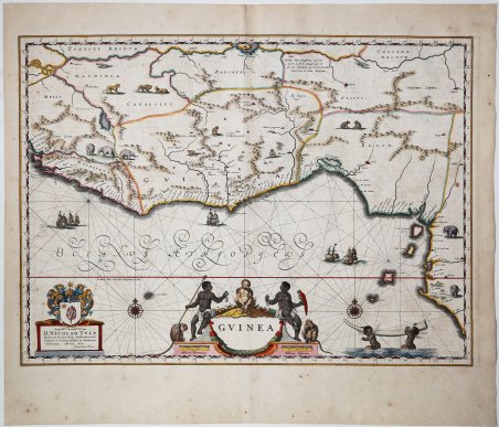
Carta marittima dell'Africa occidentale di Willem Blaeu. Mostra il Golfo di Guinea con le coste di Ghana, Togo, Benin, Nigeria, Camerun, Guinea Equatoriale e Gabon. Con elefanti, leoni e scimmie. Decorato con un bel cartiglio del titolo, velieri e due rose dei venti. Disegnata originariamente da Willem Blaeu e pubblicata nel Theatrum Orbis Terrarum ' del 1634, fu poi inclusa dal figlio Joan nel suo magistrale Atlas Maior, pubblicato per la prima volta nel 1662. La carta mostra la costa africana dalla Sierra Leone in Africa occidentale al Biafra. Come in tutte le carte europee dell'Africa della metà del XVII secolo, la costa è molto più dettagliata dell'interno, riflettendo lo stato delle conoscenze geografiche sul continente. Willem Janszoon Blaeu, avviò nel 1599 la sua attività di costruttore di globi e strumenti astronomici ad Amsterdam. Nel 1630, dopo aver comprato alcune lastre dell’atlante del Mercator da Jodocus Hondius II, fu in grado di pubblicare un volume di 60 mappe con il titolo di ' Atlantis Appendix. Cinque anni dopo, pubblicò i primi due volumi del suo atlante ' Atlas Novus ' o ' Theatrum Orbis Terrarum, ' in sei libri. Dopo la sua morte, Joan (Johannes) continuò l’opera paterna, completando l’intera serie di sei volume dell’Atlas Novus ' intorno al 1655. Fu inoltre autore di un ' Atlas Maior sive Cosmographia Blaviana, in 12 volumi pubblicati nel 1662 -72, dei quali uno dedicato all'Italia. Sebbene pubblicate dopo la morte di Willem Janszoon Blaeu (1638) le carte spesso recano il suo imprint. Non è dato sapere se fossero tutte già pronte o se i figli Johannes e Cornelis le compilarono postume. Incisione in rame, finemente colorata in epoca, ' ' Very decorative antique sea chart of West Africa by Willem Blaeu. Showing the Gulf of Guinea with the coasts of Ghana, Togo, Benin, Nigeria, Cameroon, Equatorial Guinea to Gabon. With elephants, lions and monkeys. Decorated with a beautiful title cartouche, sailing ships and two compass roses. Originally drawn by Willem Blaeu and published for the first time in Theatrum Orbis Terrarum in 1634, it was later included by his son, Joan, in the latter’s magisterial Atlas Maior, first published in 1662. The map shows the African coast from Sierra Leone in West Africa to Biafra. As with all European maps of Africa of the mid-seventeenth century, the coastline is much more detailed than the interior, reflecting the state of geographic knowledge about the continent. Willem Janszoon Blaeu, started in 1599 his business as a builder of globes and astronomical instruments in Amsterdam. In 1630, after buying some plates of the Mercator atlas from Jodocus Hondius II, he was able to publish a volume of 60 maps under the title ' Atlantis Appendix. Five years later, he published the first two volumes of his atlas ' Atlas Novus ' or ' Theatrum Orbis Terrarum, in six books. After his death, Joan (Johannes) continued his father's work, completing the entire six-volume ' Atlas Novus ' series around 1655. He was also the author of an ' Atlas Maior sive Cosmographia Blaviana, in 12 volumes published in 1662 -72, one of which was devoted to Italy. Although published after the death of Willem Janszoon Blaeu (1638) the maps often bear his imprint. It is not known whether they were all ready-made or if his sons Johannes and Cornelis completed them posthumously. Copper engraving, fine contemporary hand colour, very good condition Cfr.

Découvrez comment utiliser
Découvrez comment utiliser

