Détails
Graveurs
BLAEU Willem Janszoon
Description
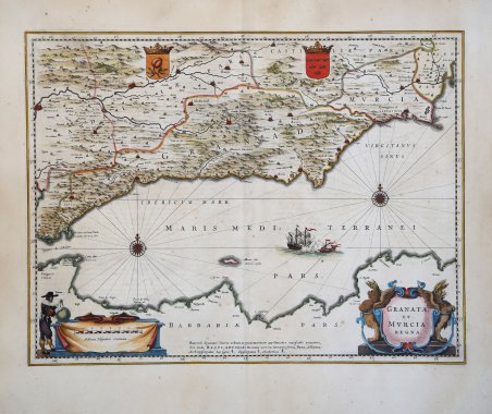
Decorativa carta geografica della regione dell'Andalusia, nel sud-est della Spagna, dallo Stretto di Gibilterra ad Alicante. La mappa è riccamente decorata con un bel cartiglio per il titolo e uno per la scala delle miglia; una scena di una battaglia navale e due rosa dei venti e, in alto, due stemmi. In basso al centro, una nota al "benevolo specator", con alcuni chiarimenti toponastici e la legenda dei simboli utilizzati. ' Inclusa nel ' Atlas Novus, edizione latina del 1640. Willem Janszoon Blaeu, avviò nel 1599 la sua attività di costruttore di globi e strumenti astronomici ad Amsterdam. Nel 1630, dopo aver comprato alcune lastre dell’atlante del Mercator da Jodocus Hondius II, fu in grado di pubblicare un volume di 60 mappe con il titolo di ' Atlantis Appendix. Cinque anni dopo, pubblicò i primi due volumi del suo atlante ' Atlas Novus ' o ' Theatrum Orbis Terrarum, ' in sei libri. Dopo la sua morte, Joan (Johannes) continuò l’opera paterna, completando l’intera serie di sei volume dell’Atlas Novus ' intorno al 1655. Fu inoltre autore di un ' Atlas Maior sive Cosmographia Blaviana, in 12 volumi pubblicati nel 1662 -72. Sebbene pubblicate dopo la morte di Willem Janszoon Blaeu (1638) le carte spesso recano il suo imprint. Non è dato sapere se fossero tutte già pronte o se i figli Johannes e Cornelis le compilarono postume. ' Incisione in rame, finemente colorata a mano, in ottimo stato di conservazione. Decorative map of the Andalusian Region - the southeastern part of Spain - from the Strait of Gibraltar to Alicante, including Marbella, Malaga, Sevilla, Granada and Almeria. The map is richly adorned with a title cartouche, scale of miles cartouche featuring a cartographer, two coats of arms, two compass roses and a sea battle. A legend at bottom identifies archbishoprics, bishoprics, and universities. ' From the Latin edition of Atlas Novus, 1640. Willem Janszoon Blaeu, started in 1599 his business as a builder of globes and astronomical instruments in Amsterdam. In 1630, after buying some plates of the Mercator atlas from Jodocus Hondius II, he was able to publish a volume of 60 maps under the title ' Atlantis Appendix. Five years later, he published the first two volumes of his atlas ' Atlas Novus ' or ' Theatrum Orbis Terrarum, in six books. After his death, Joan (Johannes) continued his father's work, completing the entire six-volume ' Atlas Novus ' series around 1655. He was also the author of an ' Atlas Maior sive Cosmographia Blaviana, in 12 volumes published in 1662 -72, one of which was devoted to Italy. Although published after the death of Willem Janszoon Blaeu (1638) the maps often bear his imprint. It is not known whether they were all ready-made or if his sons Johannes and Cornelis completed them posthumously. Copper engraving, fine contemporary hand colour, very good condition. Latin text on verso. Cfr.

Découvrez comment utiliser
Découvrez comment utiliser

