Détails
Graveurs
CHATELAIN Henri Abraham
Description
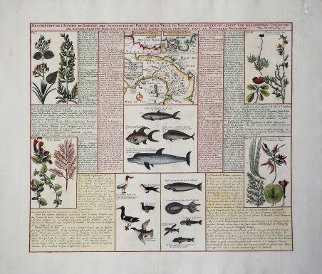
Bellissimo foglio a doppia pagina con tre piccole mappe che coprono l'Istmo di Darien e il Golfo di Panama. Le mappe sono affiancate su due lati da un testo esplicativo in francese. Questo esemplare è illustrato con sette pannelli di esempi finemente incisi della flora e della fauna della regione, tra cui pesci, uccelli e piante. La più grande delle tre carte, Carte de L'Isthme de Darien et du Golfe de Panama, mostra il percorso dell'autore e include una rosa dei venti. Tavola tratta dall'Atlas Historique, pubblicato ad Amsterdam tra il 1705 e il 1720.L'atlante, in 7 volumi, è innovativo per la sua epoca perché combina le mappe geografiche con incisioni e informazioni di carattere geografico, storico, etnografico e araldico.Incisione in rame, finemente colorata a mano, in perfette condizioni. Henri Abraham Chatelain (1684 - 1743) era un pastore ugonotto di origini parigine. È meglio conosciuto come cartografo olandese e più specificamente per il suo contributo cartografico nell’Atlas Historique ' in sette volumi, pubblicato ad Amsterdam tra il 1705 e il 1720. Innovativo per il suo tempo, l'Atlas Historique ' combinava incisioni e opere d'arte con studi di geografia, storia, etnologia, araldica e cosmografia. Alcuni studiosi suggeriscono che l'Atlas Historique ' non fu compilato esclusivamente da Henri Chatelain, come si crede comunemente, ma piuttosto fu un'impresa familiare che coinvolse Henri, suo padre Zacharie e suo fratello, sempre Zacharie. Very handsome double-page sheet has three small maps covering the Isthmus of Darien and the Gulf of Panama. The maps are flanked on two sides by explanatory text in French. This example is illustrated with seven panels of finely engraved examples of the region's flora and fauna, including fish, birds and plant life. The larger of the three maps, Carte de L'Isthme de Darien et du Golfe de Panama shows the route of the author and includes a compass rose. Taken from "Atlas Historique". Henri Abraham Chatelain (1684 - 1743) was a Huguenot pastor of Parisian origins. He is best known as a Dutch cartographer and more specifically for his cartographic contribution in the seminal seven volume ' Atlas Historique, published in Amsterdam between 1705 and 1720. Innovative for its time, the ' Atlas Historique ' combined fine engraving and artwork with scholarly studies of geography, history, ethnology, heraldry, and cosmography. Some scholarship suggests that the ' Atlas Historique ' was not exclusively compiled by Henri Chatelain, as is commonly believed, but rather was a family enterprise involving Henri, his father Zacharie and his brother, also Zacharie. Copper engraving, in excellent condition. Cfr.

Découvrez comment utiliser
Découvrez comment utiliser

