Détails
Graveurs
SALAMANCA Antonio
Description
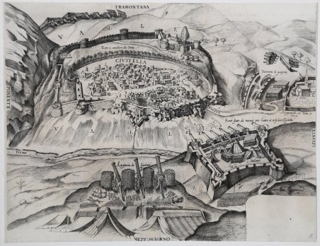
Raro documento raffigurante l’asedio di Civitella. Nel 1557 la città fu posta d'assedio da parte del francese Duca di Guisa, generale di Enrico II e alleato del papa, Paolo IV; benché feroce e violento, l’assalto non riuscì a espugnare la città,. Proprio in questa guerra, tra Francesi e Spagnoli, Civitella cambiò il suo nome in Civitella del Tronto. La vittoriosa e valorosa resistenza che il popolo della cittadella riuscì a riportare venne ben visto nell'intero Regno, tanto che ai suoi cittadini furono tolti gli oneri fiscali da pagare al Regno, per quarant'anni, e a spese del demanio regio furono restaurati gli edifici e la Fortezza. La mappa viene prodotta a Roma, probabilmente nella bottega di Antonio Salamanca e Antoine de Lafrery, che dal 1553 al 1563 erano soci nella più importante calcografia romana. La lastra viene sicuramente ralizzata in occasione dell’avvenimento, quindi nel 1557, probabilmente commissionata da autorità ecclesiastiche, oppure nel tentativo commerciale dei due editori di produrre un nuvo foglio da immettere nel mercato. La mancata vittoria nell’assedio indusse i due editori a non terminare il lavoro, come dimostrano i numerosi ripensamenti presenti nella lastra e lo spazio bianco in basso a destra, lasciato libero per il titolo e la dedicatoria. Il foglio risulta pertanto in un solo stato e molto raro. Incisione al bulino, rifilata al rame e con margini coevi aggiunti, pieghe di carta al centro, nel complesso in ottimo stato di conservazione. Rarissima. Bibliografia: Tooley, p. 25, 154; Borroni Salvadori, 221; Cartografia Rara p. 38, 30. Dimensioni 380x300. A rare document depicting the siege of Civitella. In 1557 the city was assaulted by the French Duke of Guisa, the General of Enrico II and ally of pope Paul IV; though harsh and cruel, the siege could not overcome the city. Precisely after this war between the French and the Spanish, Civitella changed its name into Civitella del Tronto. The triumphant and valiant resistance of the population was much appreciated all over the Reign so that these citizens were allowed not to pay royal taxes for the following forty years and the buildings and the Fortress were repaired with the money of the public royal domain. The map has been published in Rome, very likely in the workshop of Antonio Salamanca and Antoine de Lafrery, who created the most important partnership in Rome between 1553 and 1563. The plate has been no doubt realized to celebrate the event, therefore in 1557, probably commissioned by the ecclesiastic authorities or maybe it was an attempt of the two publishers to create a new piece of work to sell. Since the siege did not succeed, Salamanca and Lafrery did not finished the plate, as the many changes on it and the white space mint for the dedication and title show. Therefore, this work presents only one state, very rare indeed. Engraving, trimmed to platemark and contemporary margins added afterwards, paper folds in the centre, otherwise in excellent condition. Extremely rare. Bibliografia: Tooley, p. 25, 154; Borroni Salvadori, 221; Cartografia Rara p. 38, 30. Dimensioni 380x300. Cfr.

Découvrez comment utiliser
Découvrez comment utiliser

