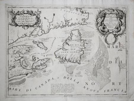
Carta dettagliata di Terranova, Labrador, Nuova Scozia e del Golfo di San Lorenzo, di Vincenzo Coronelli. Mostra la foce del San Lorenzo, con Terranova, l'isola di Capo Breton, parti della Nuova Scozia e la costa del Canada. Coronelli ha ricavato le sue informazioni da quelle di Jean Baptiste Nolin, che aveva pubblicato una carta simile, a Parigi, dieci anni prima. I pesci che circondano il cartiglio sono un'evidente allusione all'industria principale della regione. La carta di Coronelli comprende un'elaborata rappresentazione del Grand Bank, con numerosi scandagli e una rigatura differenziata per indicare le varie altitudini. È insolito, in una carta antica, vedere una topografia subacquea così accurata. Opera tratta dal ' Corso geografico universale, o sia la terra divisa nelle sue parti e subdistinta ne' suoi gran regni. Esposta in tavole geografiche ricorrette et accresciute di tutte le nuove scoperte, ad uso dell'Accademia Cosmografica degli Argonauti dal Padre Maestro Vincenzo Coronelli M. C. Cosmografo della Serenissima Republica di Venetia. Dedicata alla Santità di Nostro Signore Innocenzo XII. P. I. In Venetia, a spese dell'autore. MDCXCII. Coronelli visse un periodo di straordinaria fecondità editoriale a partire dal 1689, quando ebbe la cattedra di geografia presso l'Università alle Procuratie, con la pubblicazione, nel 1690, del primo volume dell'Atlante Veneto. In effetti sotto il nome di ' Atlante Veneto ' va tutta la raccolta di tredici opere composte nell'arco del decennio successivo, dall'Isolario ' allo ' Specchio del mare. In realtà solo alcune di tali opere possono definirsi atlante, e sono di valore molto disuguale, dato che si passa da opere originali e fondamentali come quelle citate o il ' Corso Geografico ' ad opere di compilazione o semplici raccolte di vedute. Il ' Corso Geografico ' uscì in diverse edizioni con numeri diversi di carte - sessantotto tavole nel 1689-92; di centosettantatré tavole nel 1692; duecentosessanta tavole, nel 1694-97 - che venivano vendute anche separatamente, al ritmo di sei carte al mese per due anni. Le carte furono incise tra il 1688 e il 1692 nell'attrezzatissima officina cartografica del convento dei Frari, dove lavoravano anche incisori stranieri. ' Incisione in rame in perfette condizioni. Detailed map of the Newfoundland, Labrador, Nova Scotia and the Gulf of St. Lawrence, by Vincenzo Coronelli. Showing the mouth of the St. Laurence, with Newfoundland, Cape Breton Island, and parts of Nova Scotia and the Coast of Canada. Coronelli derived his information from that of Nolin, who had published a similar map in Paris ten years earlier. The fish surrounding the cartouche are an obvious allusion to the main industry of the region. Coronelli's mapping includes an elaborate depiction of the Grand Bank with numerous soundings and differentiated stippling to indicate various elevations. It is unusual to see underwater topography render at such high definition. The map is taken from ' Corso geografico universale, o sia la terra divisa nelle sue parti e subdistinta ne' suoi gran regni. Esposta in tavole geografiche ricorrette et accresciute di tutte le nuove scoperte, ad uso dell'Accademia Cosmografica degli Argonauti dal Padre Maestro Vincenzo Coronelli M. C. Cosmografo della Serenissima Republica di Venetia. Dedicata alla Santità di Nostro Signore Innocenzo XII. P. I. In Venetia, a spese dell'autore. MDCXCII. Coronelli lived a period of extraordinary editorial fecundity starting from 1689, when he had the chair of geography at the University at the Procuratie, with the publication, in 1690, of the first volume of the ' Atlante Veneto. Under the name of ' Atlante Veneto ' goes the entire collection of thirteen works composed over the next decade, from the ' Isolario ' to the ' Specchio del mare. ' In reality, only some of these works can be defined as atlas, and are of very unequal value, since we go from original and fundamental works such as those mentioned or the ' Corso Geografico ' to works of compilation or simple collections of views. The ' Corso Geografico ' came out in several editions with different numbers of maps - sixty-eight maps in 1689-92; one hundred and seventy-three maps in 1692; two hundred and sixty maps in 1694-97 - which were also sold separately, at the rate of six a month for two years. The maps were alle engraved between 1688 and 1692 in the well-equipped cartographic workshop of the Frari convent, where foreign engravers also worked. ' Copper engraving in perfect condition. Cfr. Kershaw (Canada) 162.

Découvrez comment utiliser
Découvrez comment utiliser

