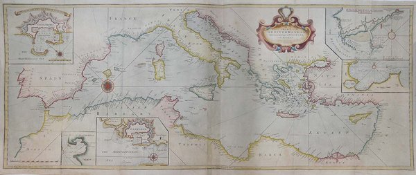
Acquaforte, stampata su due fogli di carta poi uniti, dimensioni 470x1170 mm.Doppio imprint editoriale in basso, in entrambi i fogli: Sold by Will.m Mount & Tho.s Page on Tower Hill London. Nel cartiglio con il titolo sono presenti diverse abrasioni, comprese le cifre della data 1730.Bell'esemplare, finemente colorato a mano, alcune ossidazioni in basso, nel complesso in buono stato di conservazione. Tavola nautica tratta da: The English pilot. Part III: Describing the Sea-coasts, Capes, Head-lands, Bays, Roads, Harbours, Rivers and Ports; together with the Soundings, Sands, Rocks and Dangers in the whole Mediterranean Sea, likewise the Courses and Distances from one Place to another. The Setting of the Tides and Currents. The Ebbing and Flowing of the Sea. The Bearing, Distance and Prospect of the Land, and how thwy shew themselves at Sea. Carefully corrected, with new Additions of several Ports, Harbours, Bays, and Prospects of Land, never before made Public, London, Printed for J. Mount, and T. Page.Grande carta nautica del Mar Mediterraneo, arricchita da cartigli contenenti piani nautici di Civitavecchia, Livorno, Nettuno e delle baie di Tunisi e Alessandretta. La carta è firmata da William Mount e Thomas II Page, rispettivamente figlio di Richard e Thomas I. Un esemplare della tavola, con la data 1730 è conservato in una raccolta di carte - senza titolo e data - di Charles Price nella collezione della British Library (Maps C.8.b.16, cfr. Shirley p. 1270, M.PRI-1a, 19). Charles Price finì in prigione (1731) per non aver onorato i propri debiti economici; probabile quindi che la lastra passò nelle mani della tipografia Mount & Page. La troviamo inclusa nel volume III del The English Pilot, curata dagli editori John Mount e Thomas II Page tra il 1730 ed il 1771 (cfr. Shirley, p. 1260, M.M&P-8°, 6). La data “1730” viene abrasa nelle tirature successive dell’opera. Il terzo volume dell’English Pilot, è noto in 19 diverse edizioni, a partire dal 1703 e fino al 1803. Basato sulle carte del Mediterraneo stampate da John Seller nel 1677, viene in seguito aggiornato da nuove e migliori carteBibliografia: cfr. National Maritime Museum, Catalogue of the Library - Vol. Three, Atlas & Cartography, Londra, 1971, pp. 460-462; R. Shirley, Maps in the Atlases of the British Library, Londra, 2004, pp. 1257, M.M&P-7c, (1, 2); p. 1260, M.M&P-8a (6); pp. 1263-1264, M.M&P-13b (11); p. 1270, M.PRI-1a (19); cfr. The Compleat Plattmaker: essays on Chart, Map and Globe Making in England in the Seventeenth and Eighteenth Centuries, Berkeley, 1978. Great sea chart of the Mediterranean sea, decorated with cartouches depicting the plans of the harbours of Civitavecchia, Livorno, Nettuno and the bays of Tunis and Scanderoon. The map, which has been realized by Thornton, was published in the English Pilot, a monumental collection of sea charts realized by different authors, mainly English, published by Mount & Page between 1738 and 1787. Copper engraving, printed on two sheets afterwards joined together, fine hand colour, light oxidations on lower part otherwise in excellent condition. Rare. Cfr. S. Bifolco, "Mare Nostrum, Cartografia nautica a stampa del Mar Mediterraneo" (2020), pp. 218-219, tav. 100.


Découvrez comment utiliser
Découvrez comment utiliser

