Questo sito usa cookie di analytics per raccogliere dati in forma aggregata e cookie di terze parti per migliorare l'esperienza utente.
Leggi l'Informativa Cookie Policy completa.

Grabados

JANSSONIUS Johannes

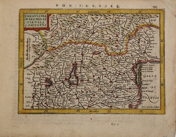
Taravisina Marchia et Tirolis Comitatus

1628

175,00 €

Antiquarius Libreria

(Roma, Italia)

Habla con el librero

Formas de Pago

Detalles

Año de publicación
1628
Lugar de impresión
Amsterdam
Formato
190 X 138
Grabadores
JANSSONIUS Johannes
Descripción
Koeman, Atlantes Neerlandici, Me 194.

Descripción

Una bella mappa del Tirolo italiano, tra cui il Lago di Garda, Brescia, Verona e il distretto di Venezia. Nel 1607 Jodocus Hondius pubblicò in versione ridotta il famoso "Atlas" di Gerard Mercator, anch'esso intitolato "Atlas Minor".Le mappe furono copiate dal grande cartografo Mercator intorno al 1580-90 o furono riduzioni delle mappe di Hondius del 1606. le numerose edizioni successive e la varietà di pubblicazioni derivate in stile simile. Quasi vent'anni dopo l'editore della mappa e dell'atlante Joannes Janssonius commissionò una nuova serie di lastre di rame che saranno incise da Peter Van Den Keere (spesso firmato Kaerius) e Abraham Goos, due dei più abili ed esperti incisori di mappe olandesi dell'epoca. Queste mappe sono state progettate elegantemente con cartigli di titolo decorativo, finemente incise e sorprendentemente dettagliate, visibili nelle loro prime stampe, come qui.Incisione in rame, finemente colorata a mano, in ottimo stato di conservazione. An attractive map of the Italian Tyrol, including Lake Garda, Brescia, Verona and the district of Venice. In 1607 Jodocus Hondius published a reduced size version of Gerhard Mercator's renowned "Atlas", itself suitably titled "Atlas Minor". The maps were copied from those of the great cartographer Mercator of around 1580-90 or were reductions of Hondius' own maps of 1606. The popularity of the smaller format and reduced price, compared with the folio issues of "Atlas", was reflected in the many subsequent editions and in the variety of derivative publications in similar style. Almost 20 years later the map and atlas publisher Joannes Janssonius commissioned a new set of copperplates to be engraved by Pieter Van Den Keere (often signed Kaerius) and Abraham Goos, two of the most proficient and experienced Dutch map engravers of the period. These maps were elegantly designed with decorative title cartouches, finely engraved and surprisingly detailed, elements particularly noticeable in their early printings, as here. Cfr. Koeman, Atlantes Neerlandici, Me 194.
Logo Maremagnum es