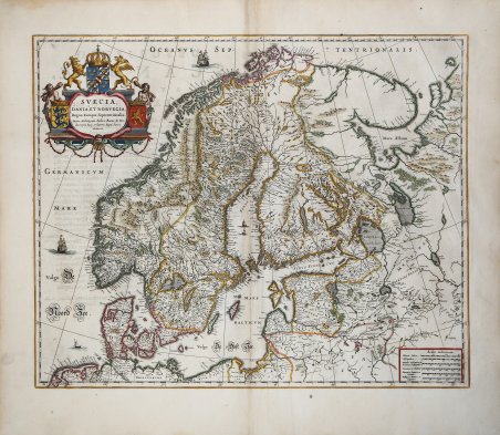
Una straordinaria carta dei regni di Svezia, Danimarca e Norvegia (Scandinavia), attribuita ad Anders Bure (1571-1646), cartografo e matematico svedese. Bure, conosciuto anche come Andreas Bureus, è noto soprattutto per la sua carta della Scandinavia in 6 fogli. Il Regno di Svezia è raffigurato nella sua massima estensione, comprendendo l'attuale Finlandia e gli Stati baltici. La carta è ricca di dettagli su città, confini politici, fiumi e topografia. Gli stemmi dei tre regni, una corona, due vecchi e due leoni sono tutti presenti nel cartiglio decorativo del titolo. Pubblicato per la prima volta da W. J. Blaeu nel 1634, questo esemplare proviene da Atlas Maior, Sive Cosmographia Blaviana, Qua Solum, Salum, Coelum, Accuratissime Describuntur. Amsterdam, J. Blaeu, 1662-65. Willem Janszoon Blaeu, avviò nel 1599 la sua attività di costruttore di globi e strumenti astronomici ad Amsterdam. Nel 1630, dopo aver comprato alcune lastre dell’atlante del Mercator da Jodocus Hondius II, fu in grado di pubblicare un volume di 60 mappe con il titolo di ' Atlantis Appendix. Cinque anni dopo, pubblicò i primi due volumi del suo atlante ' Atlas Novus ' o ' Theatrum Orbis Terrarum, ' in sei libri. Dopo la sua morte, Joan (Johannes) continuò l’opera paterna, completando l’intera serie di sei volume dell’Atlas Novus ' intorno al 1655. Fu inoltre autore di un ' Atlas Maior sive Cosmographia Blaviana, in 12 volumi pubblicati nel 1662 -72. Incisione in rame, finemente colorata a mano, in ottimo stato di conservazione. Bibliografia Van der Krogt 2, 1210:2. A striking map of the kingdoms of Sweden, Denmark and Norway (Scandinavia), attributed to Anders Bure (1571-1646), a Swedish cartographer and mathematician. Bure, also known as Andreas Bureus, is best known for his 6-sheet map of Scandinavia. The Kingdom of Sweden is shown at its largest extent, containing present day Finland and the Baltic states. The map is filled with details of towns, political boundaries, rivers, and topography. The coats of arms of the three kingdoms, a crown, two old men and two lions are all featured within the decorative title cartouche. First published by W. J. Blaeu in 1634, this example comes from Atlas Maior, Sive Cosmographia Blaviana, Qua Solum, Salum, Coelum, Accuratissime Describuntur. Amsterdam, J. Blaeu, 1662-65. Willem Janszoon Blaeu, started in 1599 his business as a builder of globes and astronomical instruments in Amsterdam. In 1630, after buying some plates of the Mercator atlas from Jodocus Hondius II, he was able to publish a volume of 60 maps under the title ' Atlantis Appendix. Five years later, he published the first two volumes of his atlas ' Atlas Novus ' or ' Theatrum Orbis Terrarum, in six books. After his death, Joan (Johannes) continued his father's work, completing the entire six-volume ' Atlas Novus ' series around 1655. He was also the author of an ' Atlas Maior sive Cosmographia Blaviana, in 12 volumes published in 1662 -72. Copperplate, with fine later hand colour, good condition. Bibliografia Van der Krogt 2, 1210:2. Cfr.


Descubre cómo utilizar
Descubre cómo utilizar

