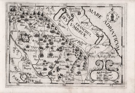
Carta geografica tratta dalla “Chorographica Descriptio Provinciarum et Conventum.”, atlante dell'ordine dei frati cappucini. Si tratta della nuova edizione dell'atlante delle province cappuccine, iniziato in forma manoscritta dal ministro generale dell'ordine, padre Silvestro da Panicale nel 1632, e che doveva servire da sussidio geografico per le visite generali. Alla sua morte il successore Padre Giovanni di Montecaliero, al quale spesso viene erroneamente attribuita la paternità delle carte, incaricò padre Massimino da Guechen di proseguire l'opera, edita per la prima volta a Roma nel 1643.A commissionare a Giovanni Battista da Cassine la Chorographica descriptio Provinciarum, et Conventuum FF. Min. S. Francisci Capucinorum fu Agostino da Latisana, 34° Ministro Generale dei cappuccini dal 1702 fino al 1709. Nell'estate di nove anni dopo, l'attento lavoro di rettifica ed aggiornamento era concluso e, retrodatando l'atlante al 1712, lo si poté stampare nel 1713 a Milano.L'opera conta 62 carte geografiche incise in rame. Vi sono raffigurate un'Europa, tra le poche mappe che rechi una data -il 1710- essendoci il 1711 per le altre datate, la Spagna con 7 carte, la Francia con 13, l'Italia con 26 carte geografiche, l'Impero con 15 fogli.L'opera mostrava visivamente la diffusione dell'ordine, infatti le diverse carte dell'atlante, che rappresentano nazioni e province, offrono per ognuna di esse la statistica completa dei conventi. Questa edizione definitiva del 1712 presenta le carte totalmente differenti, aggiornate ed arricchite. Incisione in rame, in ottimo stato di conservazione. Map taken from Chorographica Descriptio Provinciarum et Conventum., an atlas of the order of Capuchin friars. This is a new edition of the atlas of the Capuchin provinces, begun in manuscript form by the order's minister general, Father Silvestro da Panicale in 1632, and intended to serve as a geographical aid for general visits. Upon his death, his successor Father Giovanni di Montecaliero, to whom the authorship of the papers is often erroneously attributed, commissioned Father Massimino da Guechen to continue the work, which was first published in Rome in 1643. He commissioned Giovanni Battista da Cassine to write the Chorographica descriptio Provinciarum, et Conventuum FF. Min. S. Francisci Capucinorum was Augustine of Latisana, 34th Minister General of the Capuchins from 1702 until 1709. In the summer of nine years later, the careful work of rectification and updating was completed, and by backdating the atlas to 1712, it could be printed in 1713 in Milan. The work has 62 copper-engraved maps. It depicts a Europe, among the few maps bearing a date-1710-being 1711 for the others dated, Spain with 7 maps, France with 13, Italy with 26 maps, and the Empire with 15 sheets. The work visually showed the spread of the order, in fact the different maps of the atlas, representing nations and provinces, offer for each of them the complete statistics of convents. ' This final edition of 1712 presents the totally different, updated and enriched maps. Copperplate engraving, in excellent condition. Cfr.

Descubre cómo utilizar
Descubre cómo utilizar

