Detalles
Lugar de impresión
Venezia
Grabadores
CORONELLI Vincenzo
Descripción
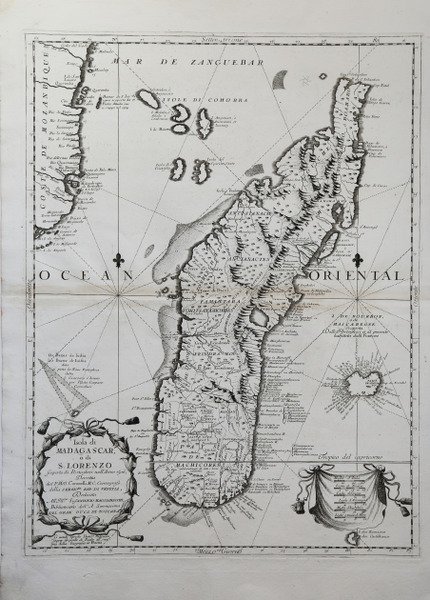
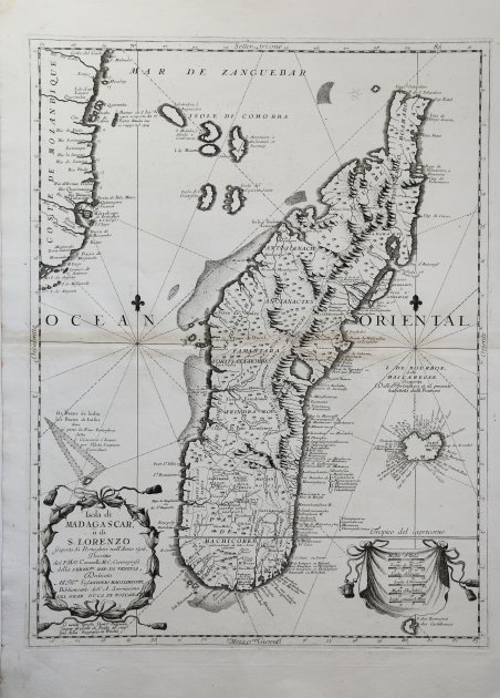
Bella e dettagliata mappa del Madagascar. Opera tratta dal ' Corso geografico universale, o sia la terra divisa nelle sue parti e subdistinta ne' suoi gran regni. Esposta in tavole geografiche ricorrette et accresciute di tutte le nuove scoperte, ad uso dell'Accademia Cosmografica degli Argonauti dal Padre Maestro Vincenzo Coronelli M. C. Cosmografo della Serenissima Republica di Venetia. Dedicata alla Santità di Nostro Signore Innocenzo XII. P. I. In Venetia, a spese dell'autore. MDCXCII. Coronelli visse un periodo di straordinaria fecondità editoriale a partire dal 1689, quando ebbe la cattedra di geografia presso l'Università alle Procuratie, con la pubblicazione, nel 1690, del primo volume dell'Atlante Veneto. In effetti sotto il nome di ' Atlante Veneto ' va tutta la raccolta di tredici opere composte nell'arco del decennio successivo, dall'Isolario ' allo ' Specchio del mare. In realtà solo alcune di tali opere possono definirsi atlante, e sono di valore molto disuguale, dato che si passa da opere originali e fondamentali come quelle citate o il ' Corso Geografico ' ad opere di compilazione o semplici raccolte di vedute. Il ' Corso Geografico ' uscì in diverse edizioni con numeri diversi di carte - sessantotto tavole nel 1689-92; di centosettantatré tavole nel 1692; duecentosessanta tavole, nel 1694-97 - che venivano vendute anche separatamente, al ritmo di sei carte al mese per due anni. Le carte furono incise tra il 1688 e il 1692 nell'attrezzatissima officina cartografica del convento dei Frari, dove lavoravano anche incisori stranieri. ' Acquaforte, impressa su carta vergata coeva, consueta traccia di piega centrale, per il resto in ottimo stato di conservazione. A large and impressive rendering of the island of Madagascar, with numerous place names around the coast. Although the west coast of the island is well defined, the east shows the fictitious concave format of earlier maps. The title is displayed in a classical floral wreath cartouche at the bottom left; at lower right there is a distance table on a draped cloth; the coast line of Mozambique fills the west corner. The lines of latitude are decorated with fleur-de-lis indicating north, and the Tropic of Cancer divides the lower portion of the map. The map is taken from ' Corso geografico universale, o sia la terra divisa nelle sue parti e subdistinta ne' suoi gran regni. Esposta in tavole geografiche ricorrette et accresciute di tutte le nuove scoperte, ad uso dell'Accademia Cosmografica degli Argonauti dal Padre Maestro Vincenzo Coronelli M. C. Cosmografo della Serenissima Republica di Venetia. Dedicata alla Santità di Nostro Signore Innocenzo XII. P. I. In Venetia, a spese dell'autore. MDCXCII. Coronelli lived a period of extraordinary editorial fecundity starting from 1689, when he had the chair of geography at the University at the Procuratie, with the publication, in 1690, of the first volume of the ' Atlante Veneto. Under the name of ' Atlante Veneto ' goes the entire collection of thirteen works composed over the next decade, from the ' Isolario ' to the ' Specchio del mare. ' In reality, only some of these works can be defined as atlas, and are of very unequal value, since we go from original and fundamental works such as those mentioned or the ' Corso Geografico ' to works of compilation or simple collections of views. The ' Corso Geografico ' came out in several editions with different numbers of maps - sixty-eight maps in 1689-92; one hundred and seventy-three maps in 1692; two hundred and sixty maps in 1694-97 - which were also sold separately, at the rate of six a month for two years. The maps were alle engraved between 1688 and 1692 in the well-equipped cartographic workshop of the Frari convent, where foreign engravers also worked. ' Copper engraving, printed on contemporary laid paper, central vertical fold, in good condition. Cfr.


Descubre cómo utilizar
Descubre cómo utilizar

