Detalles
Lugar de impresión
Parigi
Grabadores
SANSON Nicolas
Descripción
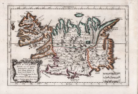
Rara carta dell'Islanda, pubblicata da Nicolas Sanson nel 1667. Qui il secondo stato della carta, con la data 1698. La carta divide l’isola in quattro parti principali; molti toponimi sono localizzati, con le caratteristiche topografiche indicate. Nel titolo si afferma che la mappa è basata sulle precedenti rappresentazioni dell'Islanda di Anders Sørensen Vedel (Andreas Velleius) e di Abraham Ortelius, la cui mappa è stata a lungo attribuita a Vedel, e Joris Carolus. Sanson ha tratto molto più da Carolus che da Ortelius, sia per la forma del paese che per la maggior parte dei toponimi. Ciò che è stato preso da Ortelius differisce principalmente dai suoi epiteti ed è disposto accanto agli stessi nomi di Carolus. Vari elementi della mappa di Carolus sono omessi in quanto è stata ridotta di quasi la metà. Nicolas Sanson (1600 - 1667) e i suoi discendenti sono stati i più influenti cartografi francesi del XVII secolo e hanno gettato le basi per l'età d'oro della cartografia francese. Sanson iniziò la sua carriera come storico e, si dice, si rivolse alla cartografia come mezzo per illustrare i suoi studi storici. Nel corso delle sue ricerche, alcune delle sue belle mappe furono sottoposte all'attenzione del re Luigi XIII che, ammirando la qualità del suo lavoro, nominò Sanson ' Geographe Ordinaire du Roi. I compiti di Sanson in questa ambita posizione comprendevano la consulenza al re su questioni di geografia e la compilazione dell'archivio cartografico reale. Nel 1644 si associò a Pierre Mariette, un affermato commerciante di stampe e incisore, il cui fiuto per gli affari e la disponibilità di capitali permisero a Sanson di pubblicare un enorme quantità di mappe. Il corpus di circa trecento carte di Sanson diede inizio all'età d'oro della cartografia francese ed è considerato il padre della cartografia francese. Incisione in rame con bella coloritura coeva, fori di tarlo perfettamente restaurati, per il resto in ottimo stato di conservazione. Scarce map of Iceland, published by Nicolas Sanson in 1667. Here the second state of the map, with the date 1698. The map is divided into its four principal parts. Many place names located, with the topographical features shown. The title states that the map is based on earlier representations of Iceland by Anders Sørensen Vedel (Andreas Velleius) and Abraham Ortelius, whose map has long been attributed to Vedel, and Joris Carolus. Sanson drew much more from Carolus than from Ortelius, both for the shape of the country and for most of the place names. What was taken from Ortelius differs mainly from its epithets and is arranged next to the same names as Carolus. Various elements of the Carolus map are omitted as it has been reduced by almost half. Nicolas Sanson (1600 - 1667) and his descendants were the most influential French cartographers of the 17th century and laid the groundwork for the Golden Age of French Cartography. Sanson started his career as a historian where, it is said, he turned to cartography as a way to illustrate his historical studies. In the course of his research some of his fine maps came to the attention of King Louis XIII who, admiring the quality of his work, appointed Sanson ' Geographe Ordinaire du Roi. ' Sanson's duties in this coveted position included advising the king on matters of geography and compiling the royal cartographic archive. In 1644 he partnered with Pierre Mariette, an established print dealer and engraver, whose business savvy and ready capital enabled Sanson to publish an enormous quantity of maps. Sanson's corpus of some three hundred maps initiated the golden age of French mapmaking and he is considered the 'Father of French Cartography.' Copperplate engraving with beautiful contemporary coloring, perfectly restored woodworm holes, otherwise in excellent condition. ' Cfr.


Descubre cómo utilizar
Descubre cómo utilizar

