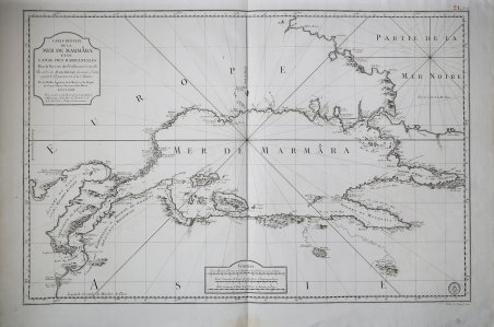
Carte Reduite de la Mer de Marmara et du Canal Des Dardanelles Pour le Service des Vaisseaux du Roy Par ordre de M. de Boynes Secretaire d'Etat, ayant, le Departement de la Marine . . . M.D.CC.LXXII . . . Carta nautica di Jacques Nicolas Bellin del Mar di Marmara e degli Stretti di Dardanelli, pubblicata in L'Hydrographie Francoise Recueil des Cartes Generales et Particulieres qui ont ete Faites pour le Service des Vaisseaux du Roy. Par ordre des Ministres de la Marine (1737-1765 circa). La carta illustra non solo le caratteristiche costiere (scandagli, ancoraggi, canali, ecc.), ma fornisce anche un resoconto dettagliato topografico lungo la costa e, occasionalmente, più all'interno. La carta si estende dal Mar Nero al Mar Mediterraneo. L’autore della carta viene indicato in J. N. Bellin, all’epoca direttore del Dépôt des cartes et plans de la Marine, un ufficio di servizio cartografico creato nel 1720 da Philippe d’Orléans (1674-1723) che, anticipando l’attuale servizio idrografico e oceanografico navale francese (SHOM), aveva il compito di raccogliere e conservare piani nautici, mappe, giornali e memorie relativi alla Marina. Il Dépôt des cartes et plans de la Marine fu avviato nel 1720, con l’acquisizione del Neptune François, sotto la direzione del capitano Charles-Hercule d’Albert de Luynes - detto Chevalier de Luynes (1674-1734) - un aristocratico e ufficiale di marina, che diresse l’istituto fino al 1722. Il Dépôt des cartes et plans de la Marine divenne rapidamente il luogo di produzione delle carte. Nel 1773 ottenne il monopolio della creazione di carte nautiche in Francia. Come si evince dagli atti del Consiglio del Re del 5 ottobre 1773: “Sua Maestà aveva ordinato nel 1720 l'istituzione di un deposito di carte, giornali e memorie marittime, osservazioni astronomiche e operazioni topografiche, dalle quali sono già state realizzate mappe migliori rispetto a quelle precedentemente utilizzate […] Sua Maestà nel suo consiglio, ha ordinato e ordina: che in futuro, tutte le carte, i portolani e le istruzioni necessarie per la condotta sia del mercantile che dei mercantili del regno, è composta, redatta e pubblicata esclusivamente presso il deposito di Sua Maestà da persone in grado di assolvere da essa […] di conseguenza, nessun particolare, scienziato, geografo, idrografo, ufficiale di marina, pilota, sarà in grado di pubblicare tali lavori senza una commissione esplicita”. Incisione in rame, con margini, in ottimo stato di conservazione. Bibliografia: cfr. O. Chapuis, A la mer comme au ciel: Beautemps-Beaupré & la naissance de lhydrographie, Parigi, 1999, pp. 151-2; National Maritime Museum, Catalogue of the Library - Vol. Three, Atlas & Cartography, Londra, 1971. Carte Reduite de la Mer de Marmara et du Canal Des Dardanelles Pour le Service des Vaisseaux du Roy Par ordre de M. de Boynes Secretaire d'Etat, ayant, le Departement de la Marine . . . M.D.CC.LXXII . . . Fine example of J.N. Bellin's map of the Sea of Marmara and the Dardanelle Straits, published in L'Hydrographie Francoise Recueil des Cartes Generales et Particulieres qui ont ete Faites pour le Service des Vaisseaux du Roy. Par ordre des Ministres de la Marine (1737-1765 circa)- The map illustrates not only coastal features (soundings, anchorages, channels, etc.), but also gives a detailed accounting of the topographical features along the coastline and occasionally further into the interior. The map extends in scope from the Black Sea to the Mediterranean Sea. The author of the chart is listed as J. N. Bellin, at the time director of the Dépôt des cartes et plans de la Marine, a cartographic service office created in 1720 by Philippe d'Orléans (1674-1723) that, anticipating today's French naval hydrographic and oceanographic service (SHOM), was tasked with collecting and preserving nautical plans, maps, journals and memoirs related to the Navy. The Dépôt des cartes et plans de la Marine was started in 1720, with the acquisition of the Neptune François, under the direction of Captain Charles-Hercule d'Albert de Luynes-known as Chevalier de Luynes (1674-1734)-an aristocrat and naval officer, who directed the institute until 1722. The Dépôt des cartes et plans de la Marine quickly became the place where charts were produced. In 1773 he obtained a monopoly on the creation of nautical charts in France. As can be seen from the acts of the King's Council of October 5, 1773: "His Majesty had ordered in 1720 the establishment of a repository of charts, journals and maritime memoirs, astronomical observations and topographical operations, from which better maps than those previously used have already been made [.] His Majesty in his council, has ordered and orders: that in the future, all maps, pilot books, and instructions necessary for the conduct of both the merchantman and merchant ships of the kingdom, shall be composed, compiled, and published exclusively at His Majesty's repository by persons capable of acquitting themselves therefrom [.] consequently, no particular, scientist, geographer, hydrographer, naval officer, pilot, shall be able to publish such works without an express commission." Copperplate engraving, with margins, in very good condition. Bibliografia: cfr. O. Chapuis, A la mer comme au ciel: Beautemps-Beaupré & la naissance de lhydrographie, Parigi, 1999, pp. 151-2; National Maritime Museum, Catalogue of the Library - Vol. Three, Atlas & Cartography, Londra, 1971. Cfr.

Descubre cómo utilizar
Descubre cómo utilizar

