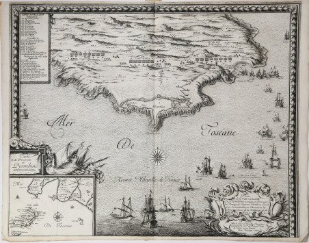
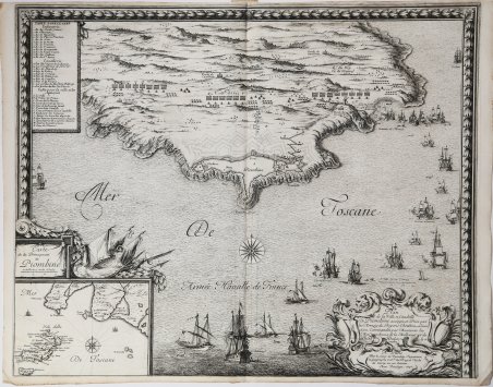
Veduta obliqua basso-alto di Piombino, una base spagnola sulla costa della Toscana che era stata catturata dai francesi nel 1646 e poi riconquistata dagli spagnoli, dal 25 maggio all'8 luglio del 1650. Guerra franco-spagnola (1645-1659). In basso a sinistra un cartiglio con la carta dell’Isola d’Elba e la costa antistante con la città di Piombino. Tavola pubblicata nell'opera ' Les glorieuses conquestes de Louis le Grand roy de France et de Navarre. Sébastien Pontault de Beaulieu (1612-1674) fu un eminente ingegnere francese, che è considerato il primo topografo militare, o piuttosto l'inventore di quest'arte, durante il regno di Luigi XIV. ' Pontault entrò nell'esercito all'età di quindici anni, e si comportò con così tanto spirito all'assedio di La Rochelle, che il Re gli diede il posto di commissario di artiglieria, anche se era così giovane. In seguito, fu presente alla maggior parte delle battaglie e degli assedi, che ha descritto, e non lasciò la vita militare fino a quando la perdita di un braccio e altre ferite, con l'avvicinarsi della vecchiaia, resero necessario il ritiro. Pontault morì il 10 agosto 1674. Era pratica di Pontault seguire l'esercito e costruire sul posto i piani delle battaglie e degli assedi, con accompagnamento storico e prospettico. La sua opera più importante è intitolata Les glorieuses Conquêtes de Louis-le-Grand: ou Recueil, de Plans et Vues des places assiegeés, et de celles ou se_sont douneés des batailles, avec des Discours. Quest'opera è una delle più magnifiche del genere, copre tutte le operazioni di guerra, dalla battaglia di Rocroi, nel 1643, alla presa di Namur, nel 1692. Pontault morì nel 1674; ma l'opera fu completata fino a questa data a spese di sua nipote, la vedova Des Roches. Questa edizione è solitamente chiamata Grand Beaulieu, per distinguerla da una in scala ridotta, in quarto oblungo, chiamata Petit Beaulieu, di cui esistono due serie, una in tre volumi, con le vedute delle azioni nei Paesi Bassi; l'altra in quattro, che include quelle della Francia. Ogni copia contiene una diversa collezione di tavole; per una descrizione dettagliata delle copie BN e BL si veda M. Pastoreau. Le tavole furono poi utilizzate nella pubblicazione del Cabinet du Roi a partire dal 1727 e sono ora conservate al Louvre. Acquaforte su rame, impressa su carta vergata coeva, in ottime condizioni. Bibliografia Pastoreau, ' Les atlas français, Beaulieu XV; Shirley, ' Maps in the Atlases of the British Library ' T.BEAU-16a A low-high oblique view of Piombino, a Spanish base on the coast of Tuscany which had been captured by the French in 1646 and shown here, retaken by the Spanish, from 25 May to 8 July in 1650. Franco-Spanish War (1645-1659). At lower left a cartouche with a map of the Island of Elba and the coast in front with the city of Piombino. Plate published in the work Les glorieuses conquestes de Louis le Grand roy de France et de Navarre. Sébastien Pontault de Beaulieu (1612–1674) was an eminent French engineer, who is considered to be the first military topographer, or rather the inventor of that art, during the reign of Louis XIV. Pontault went into the army at the age of fifteen, and behaved with so much spirit at the siege of Rochelle, that the king gave him the post of commissary of artillery, even though he was so young. He was afterwards present at most of the battles and siege, which he has described, and did not quit a military life until the loss of an arm and other wounds, with the approach of old age, rendered retirement necessary. Pontault died on 10 August 1674. From the death of this able drafts-man, there were few capable military topographers in France until the latter half of the 18th century. It was Pontault's practice to follow the army, and construct upon the spot plans of the battles and sieges, with historical and perspective accompaniments. His most important work is entitled Les glorieuses Conquêtes de Louis-le-Grand: ou Recueil, de Plans et Vues des places assiegeés, et de celles ou se_sont douneés des batailles, avec des Discours (The glorious victories of Louis the Great, produced from the drawings of the Chevalier de Beaulieu). This work is one of the most magnificent of the kind, covers all the operations of war, from the battle of Rocroi, in 1643, to the taking of Namur, in 1692. Pontault died in 1674; but the work was completed to the above date at the expense of his niece, the widow of the sieur Des Roches. This edition is usually called the Grand Beaulieu, to distinguish it from one on a reduced scale, in oblong quarto, called the Petit Beaulieu, of which there are two series, one in three volumes, with views of the actions in the Netherlands; the other in four, which includes those of France. Each copy contains a different collection of plates; for a detailed description of the BN and BL copies see Pastoreau. The plates were later used in the publication of the Cabinet du Roi from 1727 onwards and are now housed in the Louvre. Etching on copper, printed on contemporary laid paper, in very good condition. Literature Pastoreau, ' Les atlas français, Beaulieu XV; Shirley, ' Maps in the Atlases of the British Library ' T.BEAU-16a. Cfr.


Descubre cómo utilizar
Descubre cómo utilizar

