Questo sito usa cookie di analytics per raccogliere dati in forma aggregata e cookie di terze parti per migliorare l'esperienza utente.
Leggi l'Informativa Cookie Policy completa.

Prints

van MEURS Jacob

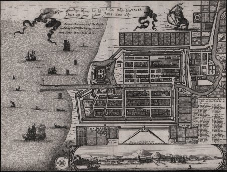
Ware affbeeldinge Wegens het Casteel ende Stadt Batavia gelegen opt groost Eylant Java Anno 1669

1669

625.00 €

Antiquarius Libreria

(Roma, Italy)

Ask for more info

Payment methods

Details

Year of publication
1669
Place of printing
Amsterdam
Size
350 X 265
Engravers
van MEURS Jacob

Description

La pianta di Batavia di Van Meurs si basa sulla precedente mappa di Batavia, molto più grande, pubblicata da Clement de Jonghe nel 1650. Batavia, l'attuale Giacarta, era il centro olandese delle attività commerciali nelle Indie Orientali. Nel mare sono raffigurate navi europee e autoctone, mentre il leone olandese si erge fiero sopra la città schematizzata. Jacob van Meurs (1619/20 - 1680), editore di mappe, incisore e libraio di Arnhem, poi Amsterdam, stampa la mappa nel 1669, per il Gedenkwaerdige gesantschappen der Oost-Indische maatschappy in 't Vereenigde Nederland di Arnoldus Montanus (1625 circa - 1683), un missionario, esploratore e teologo olandese. La carta presenta una vignetta in basso che mostra Giacarta dal mare con i vulcani Monte Gede, Monte Pangrnago e Monte Salak sullo sfondo. Incisione in rame, rifilata alla linea marginale, in buono stato di conservazione. Bibliografia Van der Krogt 4, #1951; Van der Krogt A, 54:33. Antique Map Batavia by Van Meurs titled ‘Ware affbeeldinge wegens het Casteel ende Stadt BATAVIA/gelengen opt groot eylant JAVA Anno 1669?. The plan is based on the earlier, much larger map of Batavia published by Clement de Jonghe in 1650. Batavia, present-day Jakarta, the Dutch center of trading activities in the East Indies. European and native ships are shown in the sea, while the Dutch lion stands proudly above the schematically planned city. A very fine and mid- to late 17th century black and white plan of Batavia published by Jacob van Meurs (1619/20 – 1680), map publisher, engraver and bookseller of Arnhem, later Amsterdam in Gedenkwaerdige gesantschappen der Oost-Indische maatschappy in in ‘t Vereenigde Nederland by Arnoldus Montanus (c. 1625 – 1683) in 1669, a Dutch missionary, explorer and theologian. The map has a vignette at the bottom showing Jakarta from the sea with the volcanoes Mount Gede, Mount Pangrnago and Mount Salak in the background. Copperplate, trimmed at the borderline, in good condition. Bibliografia Van der Krogt 4, #1951; Van der Krogt A, 54:33 Cfr.
Logo Maremagnum en