Details
Place of printing
Amsterdam
Engravers
KAERIUS Pieter van den Keere
Description
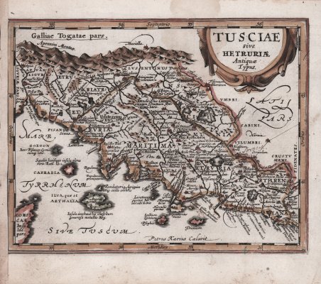
Carta della Tuscia tratta da Philippi Cluverii Introductionis in Universam Geographiam stampato nel 1676 e illustrato con 46 mappe da Petrus Kaerius (Pieter van der Keer). L'Introductionis di Philip Cluver è considerato il libro di testo geografico standard del XVII secolo, essendo egli conosciuto come il padre della moderna geografia storica. ' L'Introductionis fu pubblicato più volte tra il 1624 e il 1729; ogni edizione successiva diventava più elaborata e le ultime edizioni includevano mappe finemente incise. Questa edizione è stata pubblicata da Johann Jansson van Waesbergen. Circa la metà delle mappe sono classiche, e derivano dal Parergon di Abraham Ortelius. La carta deriva dalla Tusciae Antiquae Typus di Abraham Ortelius, pubblicata nel "Parergon" nel 1584. Le fonti cartografiche utilizzate da Ortelio sono la ' Chorographia Tusciae di Girolomano Bellarmato del 1536 (Meurer p. 113, Karrow 10/1, p. 78-80), integrata da fonti classiche, quali Livio, Plinio, Catone, Vergilio, Alicarnasso e Plutarco. Acquaforte, finemente colorata a mano, leggera gora d’acqua, per il resto in buono stato di conservazione. Bibliografia G. King, Miniature Maps, (1st ed.) p. 186; King (2nd ed.) pp. 128-29. Map of Tuscia taken from Philippi Cluverii Introductionis in Universam Geographiam printed in 1676 an illustrated with 46 maps by Petrus Kaerius (Pieter van der Keer). Philip Cluver’s Introductionis is considered the standard geographical text-book of the seventeenth century, as he is known as the father of modern historical geography. ' The Introductionis was published numerous times between 1624 and 1729 with each successive edition becoming more elaborate and the later editions including finely engraved maps. This edition was published by Johann Jansson van Waesbergen. About half the maps are classical ones derived from Abraham Ortelius' Parergon. The map is derived from Abraham Ortelius' ' Tusciae Antiquae Typus, ' published in the "Parergon" in 1584. The cartographic sources used by Ortelius are Girolomano Bellarmato's ' Chorographia Tusciae ' of 1536 (Meurer p. 113, Karrow 10/1, p. 78-80), supplemented by classical sources, such as Livy, Pliny, Cato, Vergil, Halicarnassus and Plutarch. Etching with later hand colour, light waterstains, otherwise good condition. Bibliografia G. King, Miniature Maps, (1st ed.) p. 186; King (2nd ed.) pp. 128-29. Cfr.

Find out how to use
Find out how to use

