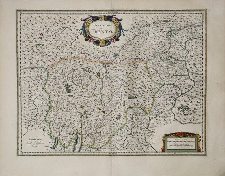
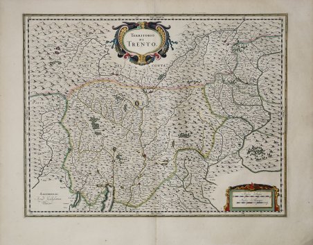
Carta geografica inserita nell'Atlas Major ' del Blaeu.Dal punto di vista cartografico la mappa deriva dalla carta del Magini già ripresa in Olanda da Jodocus Hondius. Willem Janszoon Blaeu, avviò nel 1599 la sua attività di costruttore di globi e strumenti astronomici ad Amsterdam. Nel 1630, dopo aver comprato alcune lastre dell’atlante del Mercator da Jodocus Hondius II, fu in grado di pubblicare un volume di 60 mappe con il titolo di ' Atlantis Appendix. Cinque anni dopo, pubblicò i primi due volumi del suo atlante ' Atlas Novus ' o ' Theatrum Orbis Terrarum, ' in sei libri. Dopo la sua morte, Joan (Johannes) continuò l’opera paterna, completando l’intera serie di sei volume dell’Atlas Novus ' intorno al 1655. Fu inoltre autore di un ' Atlas Maior sive Cosmographia Blaviana, in 12 volumi pubblicati nel 1662 -72, dei quali uno dedicato all'Italia. La carta compare per la prima volta nel terzo volume del ' Theatrum. ' Secondo Koeman viene pubblicata in primis nell'edizione francese del 1640, dal titolo ' Le Theatre du Monde ou Nouvel Atlas, ' Mis en lumiere par Guillaume & Jean Blaeu. ' Troisieme partie. A Amsterdam, Chez Iean & Corneille Blaeu MDCXL. Il terzo volume del ' Theatrum ' contiene 58 carte dell'Italia e 4 della Grecia (cfr. Koeman, ' Atlas Neerlandici, pp. 160-162, Bl 35A). Le carte dell'italia derivano tutte dall'opera di Giovanni Antonio Magini. Tuttavia, sembra più probabile che il Blaeu si basi sue quelle di Hendrick Hondius e Johannes Janssonius pubblicate nel ' Theatrum Italiae in quo Eius Regna, Domina, Ducatus, Et Speciatim Illorum Provinciae, Tabulis Accuratissimis, Iam, De Novo in Lucem Editio, Describunter, Quorum Sequens Pagina Indicabit, stampato ad Amsterdam da Hendrick Hondius nel 1636. ' Sebbene pubblicate dopo la morte di Willem Janszoon Blaeu (1638) le carte spesso recano il suo imprint. Non è dato sapere se fossero tutte già pronte o se i figli Johannes e Cornelis le compilarono postume. Incisione in rame, magnifica coloritura coeva, in ottimo stato di conservazione. Striking example of Blaeu's decorative map of Trentino after Giovanni Antonio Magini. Willem Janszoon Blaeu, started in 1599 his business as a builder of globes and astronomical instruments in Amsterdam. In 1630, after buying some plates of the Mercator atlas from Jodocus Hondius II, he was able to publish a volume of 60 maps under the title ' Atlantis Appendix. Five years later, he published the first two volumes of his atlas ' Atlas Novus ' or ' Theatrum Orbis Terrarum, in six books. After his death, Joan (Johannes) continued his father's work, completing the entire six-volume ' Atlas Novus ' series around 1655. He was also the author of an ' Atlas Maior sive Cosmographia Blaviana, in 12 volumes published in 1662 -72, one of which was devoted to Italy. The map first appears in the third volume of the ' Theatrum. According to Koeman it is first published in the French edition of 1640, entitled ' Le Theatre du Monde ou Nouvel Atlas, Mis en lumiere par Guillaume & Jean Blaeu. Troisieme partie. In Amsterdam, Chez Iean & Corneille Blaeu MDCXL. The third volume of the ' Theatrum ' contains 58 maps of Italy and 4 of Greece (see Koeman, ' Atlas Neerlandici, pp. 160-162, Bl 35A). The maps of Italy are all derived from the work of Giovanni Antonio Magini. However, it seems more likely that Blaeu relies on those of Hendrick Hondius and Johannes Janssonius published in ' Theatrum Italiae in quo Eius Regna, Domina, Ducatus, Et Speciatim Illorum Provinciae, Tabulis Accuratissimis, Iam, De Novo in Lucem Editio, Describunter, Quorum Sequens Pagina Indicabit, ' printed in Amsterdam by Hendrick Hondius in 1636. Although published after the death of Willem Janszoon Blaeu (1638) the maps often bear his imprint. It is not known whether they were all ready-made or if his sons Johannes and Cornelis completed them posthumously. Copperplate, with fine original colouring, in very good conditions. Cfr.


Find out how to use
Find out how to use

