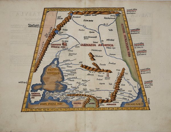
Mappa tolemaica a proiezione trapezioidale, incentrata centra su una regione storica intrisa di leggenda, di grande importanza nel primo sviluppo del commercio tra l'Asia e l'Europa, la regione della Via della Seta, tra l'Iperborei, le montagne del Caucaso e comprende una parte del Mar Caspio. Quelle regioni dell'Europa orientale che confinano con il Mar Nero sono raffigurate e denominate secondo antichi regni e popoli. Il Mar Nero ha una forma interessante. Costantinopoli non è nominata, ma il Bosforo sì. Si notano numerosi riferimenti agli Sciiti. Vengono citate anche numerose altre antiche civiltà, inclusi i Sarmati, il regno di Mitridati e le Amazzoni, ma erroneamente collocati nella regione dell’Anatolia. La Colchide è mostrata a sud di un'Anatolia molto deforme. ' La mappa è basata sulla mappa di Waldseemuller, pubblicata per la prima volta nella ' Geographia ' di Strasburgo del 1513. La prima edizione della "Geographia" di Tolomeo curata da Fries fu pubblicata a Strasburgo nel 1522, con le carte che furono copiate e nuovamente incise da quelle di Martin Waldseemüller dell'edizione di Tolomeo del 1520 e testo a cura di Pirckheimer. Nel 1525 viene stampata una seconda edizione a Strasburgo. Alla scomparsa del Fries e del Gruninger, le matrici furono acquistate dai fratelli Melchior e Gaspar Treschel che ne stampano una terza edizione a Lione nel 1535. Per il testo i due editori si servirono della supervisione di Michael Servetus, che curò la revisione del testo del Pirckheimer. Infine, nel 1541, Gaspare Treechsel pubblica a Vienne, nel Delfinato, questa quarta edizione, sempre con testo di Servetus. In questa edizione, rispetto alla prima di Strasburgo del 1522, il testo subì numerose modifiche, correzioni e aggiunte, ma i legni non furono modificati. Esemplare tratto dall’edizione del 1541, del "Claudii Ptolemaei Alexandrini Geographicae Enarrationis". Xilografia, finemente colorata a mano, in ottimo stato di conservazione. This Ptolemaic map focuses on a historical region steeped in legend, one of great importance in the early development of trade between Asia and Europe, the Silk Road region, between the Hyperborei and Caucus Mountains. It includes a portion of the Caspian Sea. Those regions of eastern Europe which border the Black Sea are depicted, and named according to ancient kingdoms and peoples. The Black Sea has an interesting shape. Constantinople is not named, but the Bosphorus is. A number of references to the Scythians are noted. ' A number of other ancient civilizations are also referred to including the Sarmatians, the kingdom of Mithridatis, and the Amazons are named, but in the wrong region or Anatolia. Colchis is shown to the south of a very misshapen Anatolia. Numerous mountain ranges and river systems are shown in detail. ' Nice example of the 1541 edition of Lorenz Fries ' map, based upon Waldseemuller's map, first published in 1513. The first edition of Ptolemy's ' Geographia ' edited by Fries was published in Strasbourg in 1522, with maps that were copied and re-engraved from those of Martin Waldseemüller of the 1520 edition of Ptolemy and text edited by Pirckheimer. In 1525 a second edition was printed in Strasbourg. At the death of Fries and Gruninger, the plates were purchased by the brothers Melchior and Gaspar Treschel, who printed a third edition in Lyon in 1535. For the text, the two editors used the supervision of Michael Servetus, who edited Pirckheimer's text. Finally, in 1541, Gaspare Treechsel published in Vienne, in the Dauphiné, this fourth edition, again with Servetus' text. In this edition, compared to the first edition of Strasbourg in 1522, the text underwent numerous changes, corrections and additions, but the wood-blocks were not changed. ' Woodcut, finely colored by hand, in excellent condition. Cfr.


Find out how to use
Find out how to use

