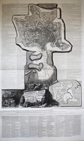
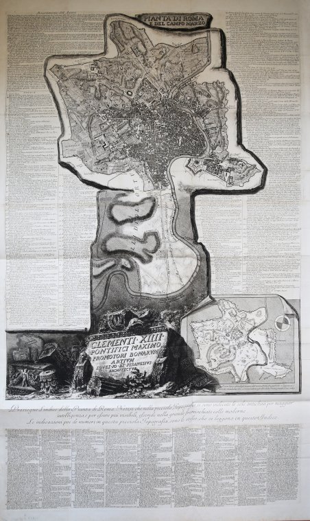
Pianta di Roma e del Campo Marzo
Payment methods
- PayPal
- Credit card
- Bank transfer
- Pubblica amministrazione
- Carta del Docente
Details
- Year of publication
- 1774
- Place of printing
- Roma
- Size
- 1200 X 700
- Engravers
- PIRANESI Giovan Battista
- Keyword
- Piante e Panorami di Roma
- Inscription description
- Hind, p. 87, [1778-9.]; Focillon 600; Ficacci 700; Wilton-Ely, II, 1008.
Description
La Pianta di Roma e del Campo Marzio appartiene al culmine della carriera del Piranesi.Nata dalla necessità di offrire una pianta di riferimento che accompagnasse le 135 tavole delle Vedute di Roma, l'opera fu intesa come tavola finale e indice dell'opera, con con cui veniva spesso venduta e rilegata. Attraverso le tre lastre che compongono questa grande piante, l'autore ha cercato di mettere in relazione le rovine superstiti di epoca antica con la contemporanea topografia di Roma, e di offrire dei riferimenti per i monumenti elencati ai due lati della mappa. Nella parte superiore ha realizzato una mappa della città contemporanea compresa entro le Mura Aureliane, estendendola a nord, a includere il territorio tra Porta del Popolo e Ponte Milvio, e inglobando anche l'area del Campo Marzio.Quest'area è mostrata nel dettaglio in una mappa isolata, in basso a destra, che mostra le antichità più importanti evidenziate da un numero che trova corrispondenza con quelli della mappa più grande. Ai lati, un indice dettagliato dei monumenti, con i numeri corrispondenti nella pianta grande, e con i rimandi ai passaggi più rilevanti delle sue opere maggiori: le Antichità Romane, Della Magnificenza ed Archittettura dei Romani e il Campo Marzio. L'opera è dedicata a papa Clemente XIV (1769-1774).La datazione dell'opera è complessa: - nel catalogo del 1792 di Francesco Piranesi, figlio dell'autore, l'opera è assegnata al 1778, data che, sebbene molto tarda - l'autore muore infatti il 9 novembre di quell'anno - viene accettata da Focillon e Hind. Questa datazione, tuttavia, è certamente basata su un errore, poiché nell'Avvertimento nella parte superiore della mappa, l'autore fa riferimento alla "approvazione che si è degnata mostrarne la Santità di N.ro Sig.re PAPA CLEMENTE XIV felicemente regnante", per cui l'opera non può essere successiva al 1774.A supporto di questa datazione, è un esemplare del Catalogo delle Opere, descritto da Scott, che contiene tre voci manoscritte per tre Vedute di Roma databili al 1774, e indica che la mappa era già disponibile.Esemplare dalla contemporanea edizione romana.Acquaforte e bulino, stampata da tre matrici su tre fogli carta vergata coeva uniti insieme, con filigrana "doppio cerchio e giglio", in ottimo stato di conservazione.Dimensione complessiva dei tre fogli: 132.1 x 82.1 cm Dimensioni complessive delle lastre: 121.2 x 71.1 cm Map of Rome and the Campus Martius, formed by three plates and usually found in association with the Vedute di Roma. He may have felt the need for a reference map to accompany collections of these plates and devised this work to fill this need. Exercising his skills in presenting formidable quantities of information coherently, he sought to relate the surviving remains of antiquity to the contemporary topography of Rome and to offer an easy reference to published information about them. He therefore produced a large map of the modern city within the Aurelian Walls, together with an extension showing the territory to the north, between Porta del Popolo and Ponte Milvio and including the Campus Martius area.This is augmented by a smaller map isolating the principal antiquities, which were marked with numbers correspondending to those in the larger map. Around these Piranesi arranged a detailed index listing the monuments according to their assigned numbers and referring to relevant passages in his major pubblications, including the Antichità Romane, Della Magnificenza ed Archittettura dei Romani and Campo Marzio.The dating of the map is problematic, since, although it is dedicated to Clemente XIV (1769-1774), Francesco Piranesi's 1792 cataloghe assigns is to 1778 and most authorities, including Giesecke, Focillon and Hind, have accepted a late, if not posthumous date; however this date is certainly based on error, since Giambattista, in his Avvertimento at the top of the main map, refers to "l'approvazione che si è degnata mostrarne la Santità di N.ro Sig.re PAPA CLEMENTE XIV felicemente regnante". Supporting evidence for an earlier date comes from an impression of the Catalogo delle Opere, referred to by Scott, which contains manuscript entries for the three Vedute di Roma datable to 1774 and indicates that the map was already available. Etching, printed from the plates on three sheets of contemporary laid paper with watermark, double circle with the fleurs-de-lys.A very good early impression for the contemporary roman edition. Cfr. Hind, p. 87, [1778-9.]; Focillon 600; Ficacci 700; Wilton-Ely, II, 1008.


