Questo sito usa cookie di analytics per raccogliere dati in forma aggregata e cookie di terze parti per migliorare l'esperienza utente.
Leggi l'Informativa Cookie Policy completa.

Prints

VAUGONDY Gilles Robert de

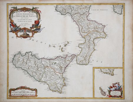
Partie Meridionale du Royaume de Naples ou se trouvent la Calabre et l'Isle et Rayaume de Sicile

1750

300.00 €

Antiquarius Libreria

(Roma, Italy)

Ask for more info

Payment methods

Details

Year of publication
1750
Place of printing
Parigi
Size
625 X 490
Engravers
VAUGONDY Gilles Robert de

Description

Carta geografica della Sicilia e Calabria intitolata “Partie Méridionale du Royaume de Naples”, esempio eccelso della produzione francese di metà settecento, disegnata da Gilles Robert de Vaugondy e suo figlio Didier nel 1750 ed edita a Parigi nel 1757 all'interno dell'Atlas Universel, non solo loro principale atlante, ma anche uno dei più importanti del XVIII secolo. I Robert de Vaugondy furono i cartografi più di successo in Francia durante l'Illuminismo, coprendo un lasso di tempo tra il 1730 ed il 1780; entrambi vennero nominati Géographe ordinaire du Roi, a dimostrazione della massima stima di cui godettero. Le loro mappe si segnalano sia per l'accuratezza e precisione, sia per la sobrietà e pulizia della composizione. Anche in questa carta geografica con la “Partie Méridionale du Royaume de Naples” la rappresentazione del territorio è accompagnata da eleganti inserti che abbelliscono senza appesantire, offrendo un senso di armonia e piacevole bellezza. ' Incisione in rame, coloritura coeva dei contorni con ritocchi, in buono stato di conservazione. This is an attractive 1750 map of southern Italy by Robert de Vaugondy. It covers the southern regions of the territories claimed by the Kingdom of Naples and extends from Agropoli south to include the island of Sicily. An inset in the bottom right quadrant features the Isle of Malta. Mt. Etna, the tallest active volcano in the region, is beautifully rendered. Sicily became a Greek colony around 750 BC and according to Greek mythology, the monster Typhon, is trapped under Mount Etna. Several important towns, cities, roads, rivers, lakes and other topographical features are noted throughout. A beautifully illustrated title cartouche adorns the top left quadrant of the map as well as the bottom right quadrant of the inset. This map was drawn by Robert de Vaugondy in 1750 and published in the 1757 issue of his Atlas Universal. The Atlas Universal was one of the first atlases based upon actual surveys. Therefore, this map is highly accurate (for the period) and has most contemporary town names correct. Copperplate with fine later hand colour, good condition. Cfr.
Logo Maremagnum en