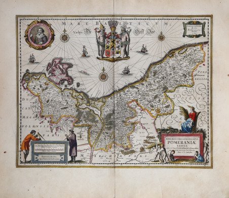
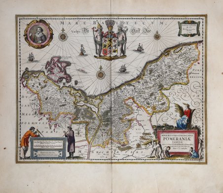
Decorativa e importante mappa decorativa del Ducato di Pomerania, che mostra città, contee, contee e fiumi. Questo esemplare proviene dall'atlante Mercator/Hondius/Jansson Hondius Nouvel Atlas. ' La mappa mostra tutta la Pomerania e l'isola di Rügen; contrassegnata con una rete di acqua e scultura di terra e 600 villaggi contrassegnati Pomorania e circa 100 di Danzica Pomerania, Wielkopolski, il Neumark, Mark Wkrzaskiej e Meclemburgo, così come i confini del ducato e paesi vicini. Numerose le decorazioni che ornano la mappa, rendendola particolarmente piacevole. Tra le altre segnaliamo il cartiglio araldico posto nel Mar Baltico - con uno scudo contenente nove stemmi della provincia del Ducato di Pomerania - una medaglia con il ritratto del principe Boguslaw XIV, tre rose dei venti con lossodromie, quattro velieri e un mostro marino. ' Johannes Janssonius, figlio dell'editore di Arnhem Jan Janssen, sposò Elisabeth Hondius, figlia di Jodocus Hondius, ad Amsterdam nel 1612. Dopo il suo matrimonio, si stabilì in questa città come libraio ed editore di materiale cartografico. Nel 1618 si stabilì ad Amsterdam accanto alla libreria di Willem Jansz. Blaeu, entrando in una seria competizione. Le sue attività non riguardavano solo la pubblicazione di atlanti e libri, ma anche di mappe singole e un vasto commercio di libri con filiali a Francoforte, Danzica, Stoccolma, Copenaghen, Berlino, Koningsbergen, Ginevra e Lione. Nel 1631 iniziò a pubblicare atlanti insieme a Henricus Hondius. Nei primi anni 1640 Henricus Hondius lasciò l'attività di pubblicazione di atlanti completamente a Janssonius. La concorrenza con Joan Blaeu, figlio e successore di Willem, nella produzione di atlanti spinse Janssonius ad ampliare il suo Atlas Novus finalmente in un'opera di sei volumi, in cui furono inseriti un atlante marino e un atlante del Vecchio Mondo. Dopo la morte di Joannes Janssonius, il negozio e la casa editrice furono continuati dagli eredi sotto la direzione di Johannes van Waesbergen (c. 1616-1681), genero di Joannes Janssonius. Le matrici degli atlanti di Janssonius furono in seguito vendute a Schenk e Valck. Acquaforte con bella colorazione originale, ottime condizioni. Decorative early map of the Duchy of Pomerania, showing towns, counties, shires and rivers. This example from is the Mercator/Hondius/Jansson atlas Hondius Nouvel Atlas. The map shows all of Pomerania and the island Rügen. On the map marked with a network of water and sculpture of land and 600 villages marked Pomoranian and about 100 of Gdansk Pomerania, Wielkopolski, the Neumark, Mark Wkrza?skiej and Mecklenburg, as well as the borders of the duchy and neighbouring countries. It is highly decorated: title cartouche with five figures and fruit, scale with two figures, a Baltic heraldic cartouche with a shield containing nine coats of arms of the Duchy of Pomerania province, a portrait medalion of Prince Boguslaw XIV, three compass roses with rhumb lines, four sailing ships and a solitary sea monster. Johannes Janssonius (Arnhem, 1588-1664), son of the Arnhem publisher Jan Janssen, married Elisabeth Hondius, daughter of Jodocus Hondius, in Amsterdam in 1612. After his marriage, he settled down in this town as a bookseller and publisher of cartographic material. In 1618 he established himself in Amsterdam next door to Blaeu’s book shop. He entered into serious competition with Willem Jansz. Blaeu. His activities not only concerned the publication of atlases and books, but also of single maps and an extensive book trade with branches in Frankfurt, Danzig, Stockholm, Copenhagen, Berlin, Koningsbergen, Geneva, and Lyon. In 1631 he began publishing atlases together with Henricus Hondius. In the early 1640s Henricus Hondius left the atlas publishing business completely to Janssonius. Competition with Joan Blaeu, Willem’s son and successor, in atlas production prompted Janssonius to enlarge his Atlas Novus finally into a work of six volumes, into which a sea atlas and an atlas of the Old World were inserted. After the death of Joannes Janssonius, the shop and publishing firm were continued by the heirs under the direction of Johannes van Waesbergen (c. 1616-1681), son-in-law of Joannes Janssonius. The copperplates from Janssonius’s atlases were afterwards sold to Schenk and Valck. Copperplate with fine original colouring, very good condition. Cfr.


Find out how to use
Find out how to use

