Details
Place of printing
Amsterdam
Description
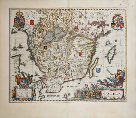
Bell'esemplare a colori della carta della Svezia meridionale di Blaeu. Carta decorativa della Gothia pubblicata nel 1640 da Johannes Blaeu. La carta è riccamente decorata con un grande cartiglio figurato, una scala di miglia e negli angoli superiori due stemmi della Gothia. Fornisce molti toponimi e indicati fiumi, laghi e montagne. Lungo la costa sono presenti dettagli di isole e fiordi. Questo esemplare proviene da ' Atlas Maior, Sive Cosmographia Blaviana, Qua Solum, Salum, Coelum, Accuratissime Describuntur. Amsterdam, J. Blaeu, 1662-65. (Van der Krogt 2, 601-3). Joan, o Johannes, Blaeu (1596-1673) era figlio di Willem Janszoon Blaeu. Ereditò lo stile cartografico meticoloso del padre e portò avanti l'officina Blaeu fino al suo incendio nel 1672. ' Dopo la morte del padre, avvenuta nel 1638, Joan e suo fratello Cornelis rilevarono la bottega paterna e Joan riprese il suo lavoro di idrografo per la Compagnia olandese delle Indie orientali. Inoltre, Joan modificò e ampliò notevolmente l'Atlas Novus del padre, pubblicato per la prima volta nel 1635. Nel frattempo, Joan perfezionava il proprio atlante. Tra il 1662 e il 1672 pubblicò l'Atlas Maior. Decorative map of Gothia published in 1640 by Johannes Blaeu. The map is richly decorated with a large figurative cartouche, scale of miles and in the upper corners with two coats of arms of Gothia, in Sweden. This map of Southern Sweden provides many place names of larger cities and small places as well. Rivers, lakes and mountains are also engraved. Along the coast many details of islands and fjords. This example comes from Atlas Maior, Sive Cosmographia Blaviana, Qua Solum, Salum, Coelum, Accuratissime Describuntur. Amsterdam, J. Blaeu, 1662-65. (Van der Krogt 2, 601-3). Joan, or Johannes, Blaeu (1596-1673) was the son of Willem Janszoon Blaeu. He inherited his father’s meticulous and striking mapmaking style and continued the Blaeu workshop until it burned in 1672. ' After his father’s death in 1638, Joan and his brother, Cornelis, took over their father’s shop and Joan took on his work as hydrographer to the Dutch East India Company. Joan also modified and greatly expanded his father’s Atlas novus, first published in 1635. All the while, Joan was honing his own atlas. He published the Atlas maior between 1662 and 1672. It is one of the most sought-after atlases by collectors and institutions today due to the attention to the detail, quality, and beauty of the maps. Cfr.


Find out how to use
Find out how to use

