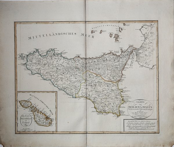
Carta geografica della Sicilia di August Ferdinand Götze, pubblicata nell’ ' Allgemeiner Handatlas ' stampato dal ' Geographische Institut ' di Weimar. La carta fu pubblicata in seguito al progetto editoriale di Friedrich Justin Bertuch (1747-1822), Adrian Christian Gaspari (1752-1830) e Franz Xaver von Zach 1754-1832) di creare un aggiornato atlante geografico di alta qualità scientifica e artistica e a prezzi misurati. Il tramite editoriale fu il Landes Industrie Comptoir, fondato da Bertuch nel 1791. Molte mappe furono incise a partire dal 1796, ma i vorticosi cambiamenti politici di quegli anni determinarono l'aggiornamento continuo delle mappe e portarono al fallimento di questa prima iniziativa editoriale. Per tali motivi le carte pubblicate in quegli anni dal Landes Industrie Comptoir, fino al 1803, sono messe in vendita come carte sciolte (al più inserite in pubblicazioni periodiche) e non facenti parte di alcun atlante. In tale prima stesura delle carte, dopo il titolo vi è – generalmente - il seguente testo “Nach den be- währtesten Hülfsmitteln neu entworfen und gezeichnet von F. Goetze. Weimar Im Verlage des Industrie Comptoir 1801”. A partire dal 1804 la carta è inserita nelle edizioni dell'Allgemeiner Handatlas, la cui prima edizione completa compare negli anni 1804-1806 ma con l'imprint editoriale del ' Geographische Institut. Nel 1803 Bertuch e August Ferdinand Götze (ca 1775- dopo 1816), autori di numerose mappe, presero in mano l'edizione dell'Handatlas ' ma, a partire dal 1804, compare come dato editoriale il nome del ' Geographische Institut ' fondato sempre a Weimar come divisione autonoma della casa editrice madre, con il compito di incidere e pubblicare carte geografiche e atlanti scolastici e storici. Con tale imprint editoriale, e con la data modificata al 1804, lo stesso rame è pubblicato nella prima edizione - dell' ' Allgemeiner Handatlas, ' di Adrian Christian Gaspari (1752-1830). RARA EDIZIONE CON DATA 1820 - non elencata nei repertori Questa carta della Sicilia è una ristampa della carta di Götze-Bertuch, pubblicata per la prima volta nel 1801. La presente edizione, sconosciuta alle bibliografie - ripropone l'edizione della carta del 1810, rispetto alla quale è modificato solo il cartiglio con il titolo, dove compare Riportiamo la descrizione di La Gumina, relativa all'edizione del 1804 (1801) della carta: "Prendendo spunto da un esemplare analogo pubblicato nel 1801 a cura del Landes Industrie Comptoir, la carta presente differisce per la specifica dell'intestazione che tiene conto della mutata denominazione della casa editrice. Il disegno della Sicilia (con graduazioni latitudinali, longitudinali e reticolo) è in larga misura riconducibile ai moduli Schmettau, con mutazioni grafi- che riconoscibili nel tratto peninsulare di C. di Gallo e nel tratto ionico tra Cap Passaro e Agosta. La nomenclatura geografica è tradotta in lingua tedesca e si riconoscono varianti toponomastiche nei casi C. Felo per Capo Ferro, Salerni per Salemi, Buscuni per Buscemi, Resultana per Resuttano e altri ancora; notevole la coesistenza di Stella Ara gona, Pelpossa e Malepasso, toponimi che testimoniano le varie vicissitudini del centro urbano di Belpasso a seguito del terremoto che aveva colpito la Sicilia nel gennaio 1693; nei sobborghi di Palermo, Virgine Maria è una località solitamente trascurata dalla pro- duzione cartografica della Sicilia; Bagaria si riferisce a un centro abitato, piuttosto che a un vasto territorio dai limiti indefiniti. Segnalate le Eolie con Volcanello tra Lipari e Vulcano. Il tracciato della rete viaria segue itinerari anche inediti per la cartografia pre cedente. I Valli si distinguono per tratti acquerellati che segnalano le loro estremità. In un inserto sono rappresentate Die inseln Malta, Gozzo und Cumino. Nel 1811 è presentata una ristampa di Allgemeiner Hand Atlas, con una riedizione della mappa riprodotta." Incisione su rame, coloritura tipografica, in ottimo stato. Map of Sicily by August Ferdinand Götze, published in the ' Allgemeiner Handatlas ' printed by the Geographische Institut in Weimar. The map was published as a result of the publishing project of Friedrich Justin Bertuch (1747-1822), Adrian Christian Gaspari (1752-1830) and Franz Xaver von Zach 1754-1832) to create an up-to-date geographic atlas of high scientific and artistic quality and at measured prices. The publishing medium was the Landes ' Industrie Comptoir, founded by Bertuch in 1791. Many maps were engraved beginning in 1796, but the whirlwind political changes of those years resulted in the continuous updating of maps and led to the failure of this early publishing venture. For these reasons the maps published in those years by the Landes ' Industrie Comptoir, until 1803, are offered for sale as loose maps (at most included in periodical publications) and not part of any atlas. In that first draft of the maps, after the title there is-usually-the following text "Nach den be- währtesten Hülfsmitteln neu entworfen und gezeichnet von F. Goetze. Weimar Im Verlage des Industrie Comptoir 1801". From 1804 the map is included in editions of the ' Allgemeiner Handatlas, the first complete edition of which appears in the years 1804-1806 but with the editorial imprint of the ' Geographische Institut. In 1803 Bertuch and August Ferdinand Götze (ca 1775-after 1816), authors of numerous maps, took over the edition of the ' Handatlas but, beginning in 1804, the name of the ' Geographische Institut, ' also founded in Weimar as an autonomous division of the parent publishing house, appears as an editorial imprint, with the task of engraving and publishing maps and scholastic and historical atlases. With that publishing imprint, and with the date changed to 1804, the same copperplate is published in the first edition - of the ' Allgemeiner Handatlas, by Adrian Christian Gaspari (1752-1830). Etching, contemporary coloring, in very good condition. ' Bibliografia: Valerio-Spagnolo "Sicilia 1477-1861", pp. 547-548, n. 282. Cfr.


Find out how to use
Find out how to use

