Anchorages in the Solomon Islands
Anchorages in the Solomon Islands | Prints | Admiralty Charts, Admiralty Charts
Anchorages in the Solomon Islands
Anchorages in the Solomon Islands | Prints | Admiralty Charts, Admiralty Charts
Payment methods
- PayPal
- Credit card
- Bank transfer
- Pubblica amministrazione
- Carta del Docente
Details
- Size
- mm 630x483
- Edition
- '900
- Engravers
- Admiralty Charts
- Keyword
- Salomon Islands - Pacific Ocean
- Designers
- Admiralty Charts
- Languages
- Italian
Description
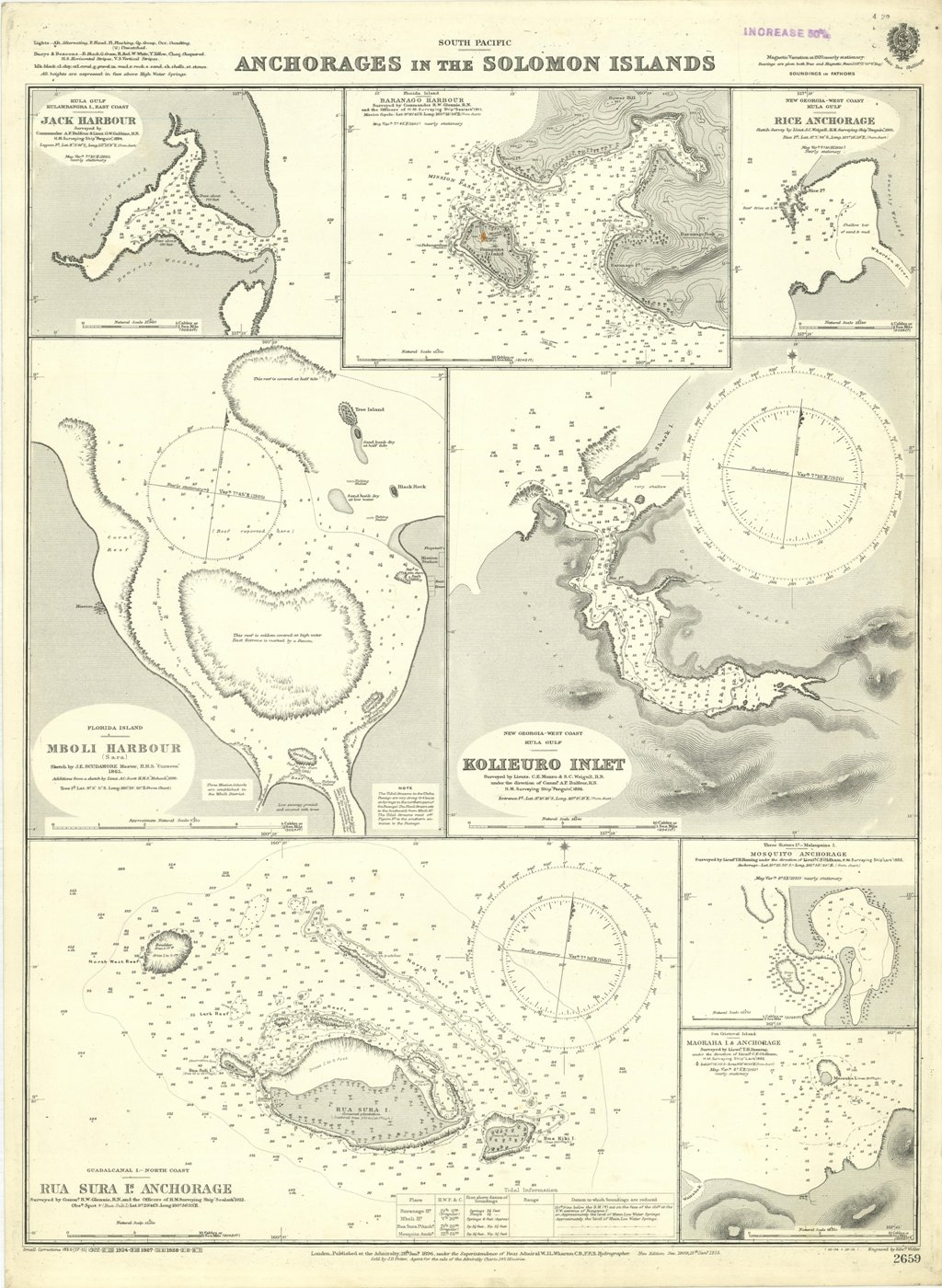
Anchorages in the Solomon Islands. In the upper part of the chart insert of Jack Harbour Surveyed by Commander A.F. Balfour & Lieut. G.W. Gubbins H.M. Surveying Ship "Penguin" 1894, Baranago Harbour Surveyed by Commander R.W. Glennie and the Officers of H.M. Surveying Ship "Sealark" 1911, Rice Anchorage Sketch Survey by Lieut. S.C. Weigall, H.M. Surveying Ship "Penguin", 1895. In the middle part of the chart insert of Mboli Harbour Sketch by J.E. Scudamore Master, H.M.S. "Curacoa" 1865 Additions from a sketch by Lieut. A.C. Scott H.M.S. "Mohawk" 1898, Kolieuro Inlet Surveyed by Lieuts. C.E. Monro & S.C. Weigall under the direction of Comm. A.F. Balfour H.M. Surveying Ship "Penguin", 1895. In the lower part of the chart insert of Rua Sura I.s Anchorage Surveyed by Comm. R.W. Glennie, and the Officers of H.M. Surveying Ship "Sealark" 1912, Mosquito Anchorage Surveyed by Lieut. T.H. Heming under the direction of Lieut. C.F. Oldham, H.M. Surveying Ship "Lark" 1882, Maoraha I. & Anchorage Surveyed by Lieut. T.H. Heming under the direction of Lieut. C.F. Oldham, , H.M. Surveying Ship "Lark" 1882. London Published at the Admiralty 28th Jan. 1896, under the Superintendence of Rear Admiral W.J.L. Wharton, Hydrographer. Small corrections: 1928. Autore: Admiralty Charts. Luogo: Salomon Islands - Pacific Ocean. Anno: '900. Tecnica: incisione. Dimensioni: 630x483 mm
Anno di pubblicazione: '900
