Questo sito usa cookie di analytics per raccogliere dati in forma aggregata e cookie di terze parti per migliorare l'esperienza utente.
Leggi l'Informativa Cookie Policy completa.

Rare and modern books

Government Of Canada

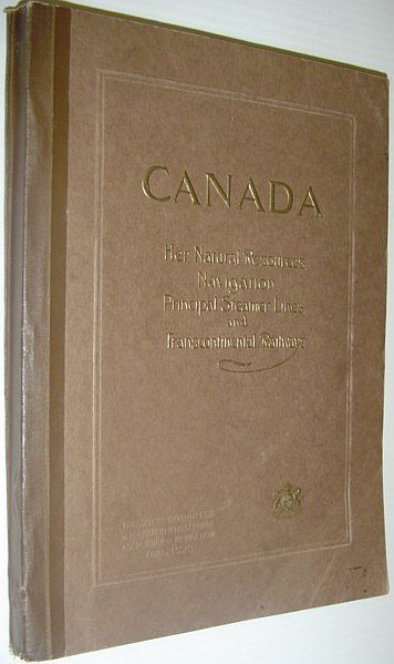
Canada: Her Natural Resources, Navigation, Principal Steamer Lines and Trans-Continental Railways - Prepared for The 12th Congress of the Permanent International Association of Navigation Congresses

The Canadian Federal Department of Marine and Fisheries, 1912

495.00 €

RareNonFiction.com

(Ladysmith, Canada)

Ask for more info

Payment methods

Details

Year of publication
1912
Place of printing
Ottawa
Author
Government Of Canada
Publishers
The Canadian Federal Department of Marine and Fisheries
Size
4to - over 9¾" - 12" tall
Edition
F First Edition
Keyword
Canada: Her Natural Resources, Navigation, Principal Steamer Lines and Trans-Continental Railways - The, 12th Congress of the Permanent International Association of, Navigation Congresses navigable distances of lakes and rivers in, north-western Ontario, Manitoba, Saskatchewan, Alberta and Mackenzie Territory, the draught and number of steamers plying on thoses waters., Similar information is given of the inland waters of British, Columbia for the first time. In the description of the, Transcontinental and Intercolonial railways much new information, appears. Original photographs of various localities were, procured from the headquarters of the railways and steamboat, lines. The book is copiously illustrated." - A. Johnston, Deputy Minister of Marine and Fisheries. "Intended as a sketch, of Canada, for the use of representatives, delegates and members of the XIIth Congress of the Permanent, International Association of Navigation Congresses, to be held at Philadelphia navigable distances of lakes and, rivers in north-western Ontario, Manitoba, Saskatchewan, Alberta and Mackenzie Territory, the draught and number of steamers plying on thoses waters., Similar information is given of the inland waters of British, Columbia for the first time. In the description of the, Transcontinental and Intercolonial railways much new information, appears. Original photographs of various localities were, procured from the headquarters of the railways and steamboat, lines. The book is copiously illustrated." - A. Johnston, Deputy Minister of Marine and Fisheries. "Intended as a sketch, of Canada, for the use of representatives, delegates and members of the XIIth Congress of the Permanent, International Association of Navigation Congresses, to be held at Philadelphia. Contains information relating to, Canada, important lines of communication on this continent, and ocean going steamers, that will be valuable to travellers engaged in business, tourists, sportsmen, yachtsmen, canoeists, surf bat Canadiana Canadian History Transportation
Binding description
S Paperback
State of preservation
Fair
Languages
English
Binding
Softcover
First edition
Yes

Description

"Contains information published for the first time, of navigable distances of lakes and rivers in north-western Ontario, Manitoba, Saskatchewan, Alberta and Mackenzie Territory; the draught and number of steamers plying on thoses waters. Similar information is given of the inland waters of British Columbia for the first time. In the description of the Transcontinental and Intercolonial railways much new information appears. Original photographs of various localities were procured from the headquarters of the railways and steamboat lines. The book is copiously illustrated." - A. Johnston, Deputy Minister of Marine and Fisheries. "Intended as a sketch of Canada, for the use of representatives, delegates and members of the XIIth Congress of the Permanent International Association of Navigation Congresses, to be held at Philadelphia. Contains information relating to Canada, important lines of communication on this continent, and ocean going steamers, that will be valuable to travellers engaged in business, tourists, sportsmen, yachtsmen, canoeists, surf bathers, and others who may find the means of satisfying any reasonable desire connected with travel, pastime or recreation." - from Introduction. Prior owner's name upon first blank leaf else unmarked. Average wear with the following exception: Affixed to the last leaf is a 35" x 21.5" fold-out map of the Dominion of Canada which shows national rail lines, resource locations, fog signals, lighthouses, wireless stations, and more. Through use, this leaf and the two which preceed it are loose but present. Two-inch opening at base of back cover and backstrip. Also included is a 21" x 17.5" fold-out map entitled "Chart of Radio-Telegraph Stations on the East Coast". Profusely illustrated with often enthralling black and white photography. Attractive gilt lettering upon embossed chocolate brown cover. A magnificent survey of Canada's natural resources and transportation infrastructure in the Pre- World War One era. Book